IMAGES TAKEN NEAR TO
Allerton Grange Croft, LEEDS, LS8 1RN
Introduction
This page details the photographs taken nearby to Allerton Grange Croft, LS8 1RN by members of the Geograph project.
The Geograph project started in 2005 with the aim of publishing, organising and preserving representative images for every square kilometre of Great Britain, Ireland and the Isle of Man.

There are currently over 7.5m images from over14,400 individuals and you can help contribute to the project by visiting https://www.geograph.org.uk
Image Map
Images are licensed for reuse under creativecommons.org/licenses/by-sa/2.0
Notes
- Clicking on the map will re-center to the selected point.
- The higher the marker number, the further away the image location is from the centre of the postcode.
Image Listing (74 Images Found)
Images are licensed for reuse under creativecommons.org/licenses/by-sa/2.0
Image
Details
Distance
1
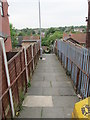
Allerton Grange Croft - Allerton Grange Avenue
Image: © Betty Longbottom
Taken: 17 Aug 2009
0.03 miles
2

Lidgett Towers
A tower block on Larkhill Lane, taking its name from Lidgett Lane nearby. At ten storeys this is not a particularly tall example of its type.
Image: © Stephen Craven
Taken: 27 Jul 2024
0.05 miles
3

Lidgett Towers - viewed from Larkhill Close
Image: © Betty Longbottom
Taken: 11 Jun 2013
0.06 miles
4

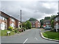
Larkhill Road - Allerton Grange Avenue
Image: © Betty Longbottom
Taken: 17 Aug 2009
0.07 miles

7

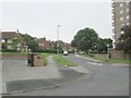
Stainburn View - Allerton Grange Drive
Image: © Betty Longbottom
Taken: 21 Jun 2013
0.10 miles
8

Allerton Grange Avenue - viewed from Stainburn View
Image: © Betty Longbottom
Taken: 17 Aug 2009
0.10 miles
9
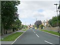
Stainburn View - Allerton Grange Avenue
Image: © Betty Longbottom
Taken: 17 Aug 2009
0.10 miles