IMAGES TAKEN NEAR TO
Norman Grove, LEEDS, LS5 3JH
Introduction
This page details the photographs taken nearby to Norman Grove, LS5 3JH by members of the Geograph project.
The Geograph project started in 2005 with the aim of publishing, organising and preserving representative images for every square kilometre of Great Britain, Ireland and the Isle of Man.

There are currently over 7.5m images from over14,400 individuals and you can help contribute to the project by visiting https://www.geograph.org.uk
Image Map
Images are licensed for reuse under creativecommons.org/licenses/by-sa/2.0
Notes
- Clicking on the map will re-center to the selected point.
- The higher the marker number, the further away the image location is from the centre of the postcode.
Image Listing (484 Images Found)
Images are licensed for reuse under creativecommons.org/licenses/by-sa/2.0
Image
Details
Distance
6
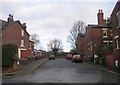
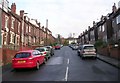
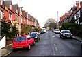
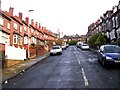
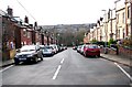
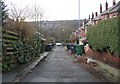
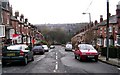
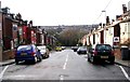
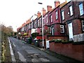
The Normans, Kirkstall
View across Abbey Road, Kirkstall. The street nearest the camera is Norman View, then Norman Grove and Norman Mount.
See a similar picture from 1953 on Leodis http://www.leodis.net/display.aspx?id=8611
Image: © Rich Tea
Taken: 28 Apr 2006
0.04 miles