IMAGES TAKEN NEAR TO
Hesketh Road, LEEDS, LS5 3HA
Introduction
This page details the photographs taken nearby to Hesketh Road, LS5 3HA by members of the Geograph project.
The Geograph project started in 2005 with the aim of publishing, organising and preserving representative images for every square kilometre of Great Britain, Ireland and the Isle of Man.

There are currently over 7.5m images from over14,400 individuals and you can help contribute to the project by visiting https://www.geograph.org.uk
Image Map
Images are licensed for reuse under creativecommons.org/licenses/by-sa/2.0
Notes
- Clicking on the map will re-center to the selected point.
- The higher the marker number, the further away the image location is from the centre of the postcode.
Image Listing (385 Images Found)
Images are licensed for reuse under creativecommons.org/licenses/by-sa/2.0
Image
Details
Distance
1
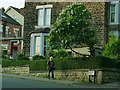
Sounding off for the NHS
Rather than just stand outside his house and clap for NHS workers at 8pm on a Thursday (as many people were doing during the Covid-19 crisis), this man was walking down the street banging a pan. He seemed happy to be photographed.
Image: © Stephen Craven
Taken: 7 May 2020
0.01 miles
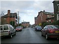
3
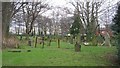
Park Mount from St Stephens churchyard, Kirkstall, Leeds
Looking out of the main gate of St Stephens churchyard, down Park Mount towards Morris Lane and St Stephens Primary School.
Image: © Rich Tea
Taken: 15 Jul 2006
0.02 miles
4
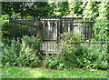
Grave enclosures to the west of St Stephen's Church, Kirkstall
Vaults and memorial stones for the Butler / Beecroft family and the Hargrave family. There are also gravestones for the Hodgson family and for Benjamin Dawson, and the group of tombs is listed, Grade II, list entry 1375213.
Image: © Humphrey Bolton
Taken: 9 Jun 2018
0.02 miles
5
Grave slabs for the Hargrave family, St Stephen's Church, Kirkstall
These two slabs record deaths from 1833 to 1930, but the lettering is remarkably uniform in style. The slabs are against the graveyard boundary wall. and are behind the family vault within railings. See also Image
Image: © Humphrey Bolton
Taken: 9 Jun 2018
0.02 miles
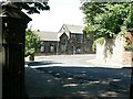
6
The Trefoil Centre, Morris Mount, Kirkstall
A meeting place for the Girl Guides.
Image: © Stephen Craven
Taken: 22 Jul 2018
0.03 miles
7
St Stephen's Graveyard - Morris Lane
Image: © Betty Longbottom
Taken: 22 Jan 2008
0.03 miles
8
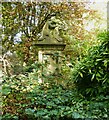
Crouched mourner, St Stephen, Kirkstall
Image: © Humphrey Bolton
Taken: 14 Oct 2023
0.03 miles
9

The Trefoil Centre, Morris Mount, Kirkstall
A local centre for the guiding movement. See also Image
Image: © Stephen Craven
Taken: 9 Apr 2021
0.03 miles
10
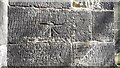
Benchmark on buttress on SW corner of tower of St Stephen's Church
1GL bolt benchmark levelled at 205.144 feet above Liverpool Datum during the 1842-1846 Liverpool to Spurn Head 1GL Survey. The surveyor's description was 'Branch Levelling From Mark No. 306. St. Stephen's Church, Kirkstall. Bolt at S. side of door in W. face of tower ; 5.03 ft. above surface'. It was verified in 1957 levelled at 62.341m above Newlyn Datum
Image: © Roger Templeman
Taken: 25 Mar 2023
0.04 miles