IMAGES TAKEN NEAR TO
Rombalds Way, ILKLEY, LS29 6GQ
Introduction
This page details the photographs taken nearby to Rombalds Way, LS29 6GQ by members of the Geograph project.
The Geograph project started in 2005 with the aim of publishing, organising and preserving representative images for every square kilometre of Great Britain, Ireland and the Isle of Man.

There are currently over 7.5m images from over14,400 individuals and you can help contribute to the project by visiting https://www.geograph.org.uk
Image Map (Loading...)


Getting Data...Please wait
Leaflet Map data © OpenStreetMap
Images are licensed for reuse under creativecommons.org/licenses/by-sa/2.0
Notes
- Clicking on the map will re-center to the selected point.
- The higher the marker number, the further away the image location is from the centre of the postcode.
Image Listing (21 Images Found)
Images are licensed for reuse under creativecommons.org/licenses/by-sa/2.0
Image
Details
Distance
1
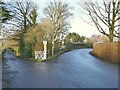
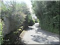
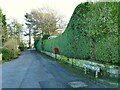
Burley Lane approaching the railway bridge
There is a spot height of 114 metres on the map at this point. To the left is Clarence Drive, a private road.
Image: © Stephen Craven
Taken: 30 Dec 2020
0.04 miles
2
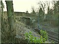
Burley Lane railway bridge
The road crosses the line between Menston and Burley-in-Wharfedale.
Image: © Stephen Craven
Taken: 30 Dec 2020
0.05 miles
3
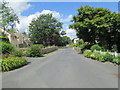
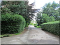
Burley Lane - viewed from Westbourne Drive
Image: © Betty Longbottom
Taken: 3 Aug 2013
0.10 miles
4
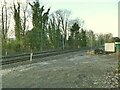
Network Rail access point, Burley Lane
Image: © Stephen Craven
Taken: 30 Dec 2020
0.10 miles
5
Burley Lane - viewed from Westbourne Drive
Image: © Betty Longbottom
Taken: 3 Aug 2013
0.13 miles
6
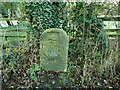
Boundary stone between Menston and Burley
Image: © Stephen Craven
Taken: 30 Dec 2020
0.14 miles
7
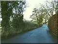
Menston Old Lane
To provide the context for a boundary stone on the left side of the road Image
Image: © Stephen Craven
Taken: 30 Dec 2020
0.14 miles
8
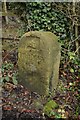
Urban District Boundary Stone
Situated in Old Lane Menston.
Image: © Andrew Riley
Taken: 16 Nov 2019
0.14 miles
9
Westbourne Drive
Although this is a through road leading to Menston railway station, part of it is unsurfaced to make it unsuitable as a through route for most motor vehicles. Note the postbox.
Image: © Stephen Craven
Taken: 30 Dec 2020
0.14 miles
10
Westbourne Drive - viewed from St John's Park
Image: © Betty Longbottom
Taken: 3 Aug 2013
0.14 miles