IMAGES TAKEN NEAR TO
Moor Lane, ILKLEY, LS29 6AS
Introduction
This page details the photographs taken nearby to Moor Lane, LS29 6AS by members of the Geograph project.
The Geograph project started in 2005 with the aim of publishing, organising and preserving representative images for every square kilometre of Great Britain, Ireland and the Isle of Man.

There are currently over 7.5m images from over14,400 individuals and you can help contribute to the project by visiting https://www.geograph.org.uk
Image Map
Images are licensed for reuse under creativecommons.org/licenses/by-sa/2.0
Notes
- Clicking on the map will re-center to the selected point.
- The higher the marker number, the further away the image location is from the centre of the postcode.
Image Listing (11 Images Found)
Images are licensed for reuse under creativecommons.org/licenses/by-sa/2.0
Image
Details
Distance
2
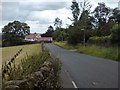
Bleach Mill Lane
Track heading towards Burley Woodhead from Menston - adopted by the Ebor Way long distance footpath and the Dales Way Leeds Link.
Image: © Chris Heaton
Taken: 11 Sep 2020
0.11 miles
3
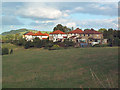
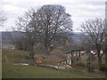
Semis on the outskirts of Menston
With Otley Chevin in the background and looking over open country, these semis are in Bleach Mill Lane. Seen from the Ebor Way footpath.
Image: © David Spencer
Taken: 24 Aug 2005
0.13 miles
5
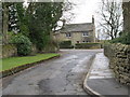
Bleach Mill Lane - viewed from Main Street
Image: © Betty Longbottom
Taken: 17 Apr 2013
0.20 miles
6
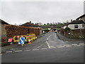
Moor Lane - viewed from Main Street
Image: © Betty Longbottom
Taken: 17 Apr 2013
0.21 miles
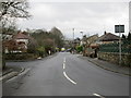
7
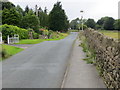
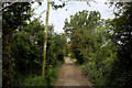
Moor Lane near Gynesta
Looking north-westward.
Image: © Peter Wood
Taken: 11 Aug 2017
0.21 miles
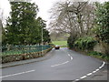
8
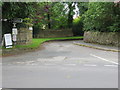
Bleach Mill Lane at its junction with Moor Lane in Menston
Looking north-westward.
Image: © Peter Wood
Taken: 11 Aug 2017
0.21 miles
9
Main Street - viewed from Bleach Mill Lane
Image: © Betty Longbottom
Taken: 17 Apr 2013
0.22 miles