IMAGES TAKEN NEAR TO
Priestley Close, PUDSEY, LS28 9NJ
Introduction
This page details the photographs taken nearby to Priestley Close, LS28 9NJ by members of the Geograph project.
The Geograph project started in 2005 with the aim of publishing, organising and preserving representative images for every square kilometre of Great Britain, Ireland and the Isle of Man.

There are currently over 7.5m images from over14,400 individuals and you can help contribute to the project by visiting https://www.geograph.org.uk
Image Map
Images are licensed for reuse under creativecommons.org/licenses/by-sa/2.0
Notes
- Clicking on the map will re-center to the selected point.
- The higher the marker number, the further away the image location is from the centre of the postcode.
Image Listing (186 Images Found)
Images are licensed for reuse under creativecommons.org/licenses/by-sa/2.0
Image
Details
Distance
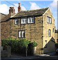
2
Priestley Close from Priestley Drive
Image: © Betty Longbottom
Taken: 23 Feb 2009
0.04 miles
3
Priestley View - Priestley Gardens
Image: © Betty Longbottom
Taken: 23 Feb 2009
0.04 miles
4
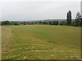
Athletics track behind St Joseph's school
It is not clear whether these sports facilities belong to Pudsey Grangefield School Image, or to St Joseph's school Image, or are public facilities: there is no barrier, gate or signage at the entrance from Mount Pleasant to suggest they are private or school property, and the few signs (such as "no dogs") bear the name of Leeds City Council. The grass had been recently cut.
Image: © Stephen Craven
Taken: 4 Jun 2016
0.06 miles
5
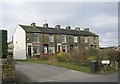
East View Cottages - Priestley Gardens
Image: © Betty Longbottom
Taken: 23 Feb 2009
0.07 miles
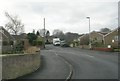
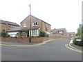
6
St Joseph's Way
The road takes its name from the nearby Catholic church. The spine road of the estate shown here follows the route of the former Pudsey railway line (see shared description). See also Image
Image: © Stephen Craven
Taken: 20 Mar 2022
0.07 miles
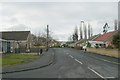
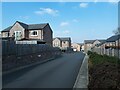
7
St Joseph's Way, Pudsey
This appears to be quite a new development off Mount Pleasant: aerial Google maps still show it as an undeveloped site. It takes its name from the nearby Catholic church. The spine road of the estate shown here follows the route of the former Pudsey railway line (see shared description).
Image: © Stephen Craven
Taken: 4 Jun 2016
0.08 miles
8
St Joseph's Catholic Primary School - Mount Pleasant Road
Image: © Betty Longbottom
Taken: 27 Oct 2010
0.08 miles
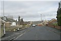
9

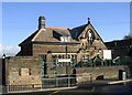
Old stone cottages, Lane End
Although this is now a 'give way' junction, the road in the foreground and going round to the right is Lane End and old maps show this was a bend with houses on the corner and no road to the left. The leftmost house bears a date of 1831 Image, but not of its construction, so they must be older than that.
Image: © Stephen Craven
Taken: 20 Mar 2022
0.08 miles