IMAGES TAKEN NEAR TO
Southroyd Park, PUDSEY, LS28 8BA
Introduction
This page details the photographs taken nearby to Southroyd Park, LS28 8BA by members of the Geograph project.
The Geograph project started in 2005 with the aim of publishing, organising and preserving representative images for every square kilometre of Great Britain, Ireland and the Isle of Man.

There are currently over 7.5m images from over14,400 individuals and you can help contribute to the project by visiting https://www.geograph.org.uk
Image Map (Loading...)


Getting Data...Please wait
Leaflet Map data © OpenStreetMap
Images are licensed for reuse under creativecommons.org/licenses/by-sa/2.0
Notes
- Clicking on the map will re-center to the selected point.
- The higher the marker number, the further away the image location is from the centre of the postcode.
Image Listing (195 Images Found)
Images are licensed for reuse under creativecommons.org/licenses/by-sa/2.0
Image
Details
Distance
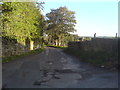
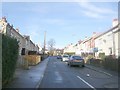
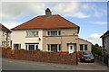
1
Southroyd Park, Pudsey
These houses were built by the local authority between the two World Wars as part of a small housing estate. They are two-up, two-down dwellings with a coal store and bathroom off the kitchen; the sitting room was heated by a cast iron cooking range with back boiler; the lavatory was upstairs. At times the kitchen used to "run wick wi' black-clocks". No housing development is shown here on the 1940s OS map. Here we are at the southernmost extent of Pudsey's built-up-area quite close to Fulneck Moravian village and school.
Image: © michael ely
Taken: 25 Jul 2006
0.02 miles
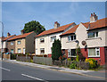
2
Nos. 8 and 7 Southroyd Park
There is an Ordnance Survey benchmark Image on the side of the right hand house near its front corner
Image: © Roger Templeman
Taken: 15 Apr 2017
0.03 miles
3

Benchmark on #7 Southroyd Park
Ordnance Survey cut mark benchmark described on the Bench Mark Database at www.bench-marks.org.uk/bm83443
Image: © Roger Templeman
Taken: 15 Apr 2017
0.03 miles
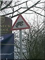
5
Fire Tank valve
At the junction of Fartown and Hare Lane. An unusual feature on an English water supply network, I presume the fire tank is a reserve of water near the end of a system to ensure capacity for fighting fires where flow rates would otherwise be inadequate.
Image: © Stephen Craven
Taken: 19 May 2020
0.03 miles
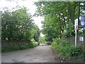
6
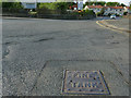
The Entrance to the Fulneck Moravian Settlement
Image: © Betty Longbottom
Taken: 24 Mar 2007
0.04 miles
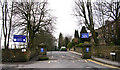
7
Southroyd Park - looking towards Southroyd Rise
Image: © Betty Longbottom
Taken: 19 Jan 2011
0.04 miles
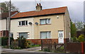
9
Nos. 24 and 23 Southroyd Park
There is an Ordnance Survey benchmark Image on the side of the right hand house near its front corner
Image: © Roger Templeman
Taken: 15 Apr 2017
0.05 miles