IMAGES TAKEN NEAR TO
Slaters Road, PUDSEY, LS28 6EY
Introduction
This page details the photographs taken nearby to Slaters Road, LS28 6EY by members of the Geograph project.
The Geograph project started in 2005 with the aim of publishing, organising and preserving representative images for every square kilometre of Great Britain, Ireland and the Isle of Man.

There are currently over 7.5m images from over14,400 individuals and you can help contribute to the project by visiting https://www.geograph.org.uk
Image Map (Loading...)


Getting Data...Please wait
Leaflet Map data © OpenStreetMap
Images are licensed for reuse under creativecommons.org/licenses/by-sa/2.0
Notes
- Clicking on the map will re-center to the selected point.
- The higher the marker number, the further away the image location is from the centre of the postcode.
Image Listing (394 Images Found)
Images are licensed for reuse under creativecommons.org/licenses/by-sa/2.0
Image
Details
Distance
1
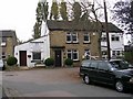
Wheater's Fold - Stanningley
The premises shown belong to Samuel Keighley & Son, Funeral Directors.
Image: © Betty Longbottom
Taken: 25 Oct 2007
0.02 miles
2
Martial Arts Academy - Town Street, Stanningley
Image: © Betty Longbottom
Taken: 29 Apr 2018
0.02 miles
3
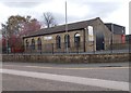
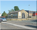
AEGIS, Town Street, Stanningley
A martial arts centre in the former Stanningley School, dated 1822.
Image: © Stephen Craven
Taken: 3 Nov 2019
0.02 miles
4
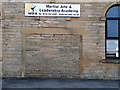
Inscription on the former Stanningley school
A rather weathered inscription (not surprisingly after nearly 200 years) on the lintel of a blocked doorway records the following -
"Stanningley School. Built by subscription to be a School for ever and for the Children of the Poor of all Classes to be taught gratuitously on Sundays. AD : MDCCCXXII" (the date translates as 1822). The building is now a martial arts centre Image so you could say it is still a school of sorts.
Image: © Stephen Craven
Taken: 3 Nov 2019
0.02 miles
5
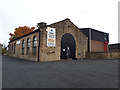
Aegis Martial Arts and Leadership Academy, Stanningley
A neat building, presumably originally industrial.
Image: © Humphrey Bolton
Taken: 17 Sep 2020
0.02 miles
6
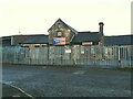
Delta Filter Services, Slaters Fold, Stanningley
Previously it was a joinery workshop Image where it is described as a former railway property. I'm not convinced, as from old maps it looks to have been outside the station site.
Image: © Stephen Craven
Taken: 12 May 2021
0.02 miles
7
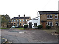
Woods Row / Wheaters Fold, off Town Street, Stanningley
Old buildings set back just off the main street.
The 1908 map shows that the front of the building to the right (Wheaters Fold) was on the line of the "Municipal, Co. [Constituency?], Parliamentary and Union boundary". The boroughs concerned would have been Bramley (this side) and Pudsey. Both are now in the unitary authority of Leeds. The Union boundary would be the Poor Law Unions of Bramley and North Bierley (including Pudsey) which no longer exist. The Parliamentary constituency between Leeds West and Pudsey now runs along the railway line behind the further houses.
Image: © Stephen Craven
Taken: 3 Nov 2019
0.02 miles

9
Stanningley Firesides - Town Street
Image: © Betty Longbottom
Taken: 30 Mar 2014
0.03 miles
10
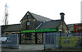
Former Stanningley Railway Station property
Now used as business premises
Image: © Betty Longbottom
Taken: 19 Mar 2007
0.03 miles