IMAGES TAKEN NEAR TO
Victoria Mews, LEEDS, LS27 9DE
Introduction
This page details the photographs taken nearby to Victoria Mews, LS27 9DE by members of the Geograph project.
The Geograph project started in 2005 with the aim of publishing, organising and preserving representative images for every square kilometre of Great Britain, Ireland and the Isle of Man.

There are currently over 7.5m images from over14,400 individuals and you can help contribute to the project by visiting https://www.geograph.org.uk
Image Map
Images are licensed for reuse under creativecommons.org/licenses/by-sa/2.0
Notes
- Clicking on the map will re-center to the selected point.
- The higher the marker number, the further away the image location is from the centre of the postcode.
Image Listing (184 Images Found)
Images are licensed for reuse under creativecommons.org/licenses/by-sa/2.0
Image
Details
Distance
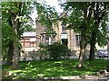
2
Morley Manor
The original Manor House of Morley was demolished in the 1930s; the name has been adopted by this residential care home that occupies what is probably a 19th century property.
Image: © Stephen Craven
Taken: 18 Apr 2022
0.02 miles
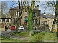
3
Old mill building, Brunswick Street, Morley
Part of a former woollen mill, the rest of which has been demolished for more modern housing. It looks to have been converted to apartments.
Image: © Stephen Craven
Taken: 18 Apr 2022
0.03 miles
5
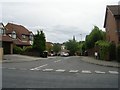
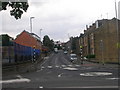
Victoria Grove Way - Victoria Road
Image: © Betty Longbottom
Taken: 21 Sep 2009
0.06 miles
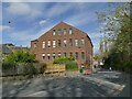
6
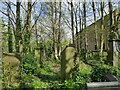
Rehoboth burial ground, Dawson Hill, Morley
Rehoboth Congregational Chapel was built in 1835. The chapel itself closed in the 1960s and was demolished a long time ago; its graveyard is unfenced but rather overgrown, especially at the west end.
Image: © Stephen Craven
Taken: 18 Apr 2022
0.06 miles
7
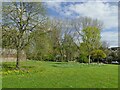
Morley Hole
Otherwise known as Morley Bottoms, this is an area that was cleared of slum housing in the 1930s and never rebuilt. It is now at least de-facto a public open space.
Image: © Stephen Craven
Taken: 18 Apr 2022
0.06 miles
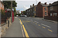
8
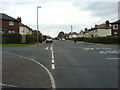
Ingle Avenue, Morley.
1920's corporation housing. Showing the junction with Ingle Grove.
Image: © Steve Partridge
Taken: 27 Sep 2006
0.06 miles
9
Victoria Road - viewed from Asquith Avenue
Image: © Betty Longbottom
Taken: 1 Aug 2011
0.07 miles
10

Victoria Grange Way - Victoria Road
Image: © Betty Longbottom
Taken: 3 Oct 2011
0.08 miles