IMAGES TAKEN NEAR TO
Talbot Yard, LEEDS, LS26 9JJ
Introduction
This page details the photographs taken nearby to Talbot Yard, LS26 9JJ by members of the Geograph project.
The Geograph project started in 2005 with the aim of publishing, organising and preserving representative images for every square kilometre of Great Britain, Ireland and the Isle of Man.

There are currently over 7.5m images from over14,400 individuals and you can help contribute to the project by visiting https://www.geograph.org.uk
Image Map
Images are licensed for reuse under creativecommons.org/licenses/by-sa/2.0
Notes
- Clicking on the map will re-center to the selected point.
- The higher the marker number, the further away the image location is from the centre of the postcode.
Image Listing (42 Images Found)
Images are licensed for reuse under creativecommons.org/licenses/by-sa/2.0
Image
Details
Distance
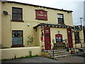
1
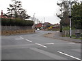
Lower Mickletown - viewed from Pinfold Lane
Image: © Betty Longbottom
Taken: 1 Apr 2016
0.04 miles
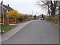

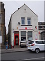
7
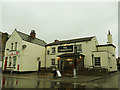
Post office and the Commercial Inn, Main Street, Mickletown
Image: © Stephen Craven
Taken: 3 Mar 2019
0.11 miles
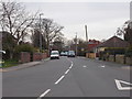
9
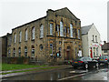
Methley Methodist Church, Main Street, Mickletown
The 1908 map shows no fewer than three Methodist chapels along this street, as well as one Anglican church. Only this one remains in use as a place of worship.
Image: © Stephen Craven
Taken: 3 Mar 2019
0.11 miles
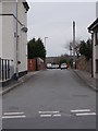
10
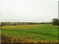
Mickletown Ings SSSI - open field
The SSSI covers a large area north of Mickletown village up to the route of the former Aire & Calder Navigation. This is the view to the east of Pit Lane.
Image: © Stephen Craven
Taken: 3 Mar 2019
0.12 miles