IMAGES TAKEN NEAR TO
Savile Road, LEEDS, LS26 9HS
Introduction
This page details the photographs taken nearby to Savile Road, LS26 9HS by members of the Geograph project.
The Geograph project started in 2005 with the aim of publishing, organising and preserving representative images for every square kilometre of Great Britain, Ireland and the Isle of Man.

There are currently over 7.5m images from over14,400 individuals and you can help contribute to the project by visiting https://www.geograph.org.uk
Image Map
Images are licensed for reuse under creativecommons.org/licenses/by-sa/2.0
Notes
- Clicking on the map will re-center to the selected point.
- The higher the marker number, the further away the image location is from the centre of the postcode.
Image Listing (56 Images Found)
Images are licensed for reuse under creativecommons.org/licenses/by-sa/2.0
Image
Details
Distance
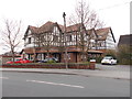
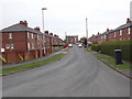
2
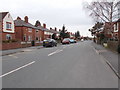
Savile Road - viewed from St Margaret's Avenue
Image: © Betty Longbottom
Taken: 1 Apr 2016
0.04 miles
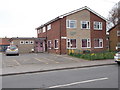
4
Ashlands, Main Street, Mickletown - closed
A former care home Image which has closed in the last two years, and looks like it is about to be demolished.
Image: © Stephen Craven
Taken: 3 Mar 2019
0.05 miles
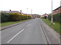
6
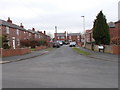
St Margaret's Road - St Margaret's Avenue
Image: © Betty Longbottom
Taken: 1 Apr 2016
0.05 miles
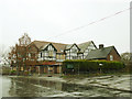
7
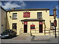
The Commercial.
Yellow pub at Mickletown.
Image: © Steve Partridge
Taken: 10 Apr 2006
0.05 miles
8
Savile Road - viewed from St Margaret's Avenue
Image: © Betty Longbottom
Taken: 1 Apr 2016
0.06 miles
9
St Margaret's Road - St Margaret's Avenue
Image: © Betty Longbottom
Taken: 1 Apr 2016
0.06 miles
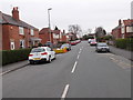
10
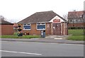
Mickletown Community Centre - Main Street
Image: © Betty Longbottom
Taken: 1 Apr 2016
0.06 miles