IMAGES TAKEN NEAR TO
Wakefield Road, LEEDS, LS26 8DJ
Introduction
This page details the photographs taken nearby to Wakefield Road, LS26 8DJ by members of the Geograph project.
The Geograph project started in 2005 with the aim of publishing, organising and preserving representative images for every square kilometre of Great Britain, Ireland and the Isle of Man.

There are currently over 7.5m images from over14,400 individuals and you can help contribute to the project by visiting https://www.geograph.org.uk
Image Map
Images are licensed for reuse under creativecommons.org/licenses/by-sa/2.0
Notes
- Clicking on the map will re-center to the selected point.
- The higher the marker number, the further away the image location is from the centre of the postcode.
Image Listing (63 Images Found)
Images are licensed for reuse under creativecommons.org/licenses/by-sa/2.0
Image
Details
Distance
3
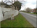
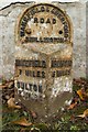
Old milestone
Looking along the A642 road towards Oulton and Wakefield. A cut benchmark can be seen near the base of the stone. When these milestones were set up the stone was left bare but many have been given a coat of white or black paint during the last 130 years. There was a 12 mile long tollroad between Wakefield and Aberford first enacted in 1741 but no older milestones have been found and only 4 of the WRCC ones are still in situ.
Image: © Chris Minto
Taken: 5 Mar 2023
0.06 miles
4
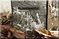
Cut bench mark on milestone (Aberford 6) on Wakefield Road
Bench Mark Database: https://www.bench-marks.org.uk/bm101955
Image: © Mark Anderson
Taken: 14 Nov 2018
0.06 miles
5
Milestone (Aberford 6), Wakefield Road, Swillington
There is a cut bench mark on the side to the left of the photograph and a closer view can be seen here: Image A wider view can be seen here: Image
Image: © Mark Anderson
Taken: 14 Nov 2018
0.06 miles
6
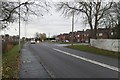
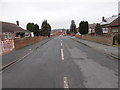
Wakefield Road near the entrance to Home Farm
There is a milestone to the right of the photograph and closer views can be seen here: Image and here: Image
Image: © Mark Anderson
Taken: 14 Nov 2018
0.06 miles
7
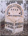
Old Milestone, A642, Wakefield Road
Located on the East side of road, on banking in corner near wall. Metal plate attached to stone post, Brayshaw & Booth casting design, 19th century. Alternative views see http://www.geograph.org.uk/photo/5975212 & http://www.geograph.org.uk/photo/5975217 & http://www.geograph.org.uk/photo/5975209
Inscription reads: WAKEFIELD / 7 MILES / OULTON / 2 MILES // ABERFORD / 6 MILES // WAKEFIELD & ABERFORD / ROAD / SWILLINGTON // BRAYSHAW & BOOTH / MAKERS / LIVERSEDGE
Grade II listed by Historic England. see https://historicengland.org.uk/listing/the-list/list-entry/1247696
Milestone Society National ID: YW_WKAF07
Image: © Christine Minto
Taken: 9 Feb 2021
0.06 miles
8
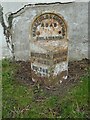
Old milestone
This West Riding CC milestone set up in 1893/94 is at the southern end of Swillington near the entrance to Home Farm. The metal attachment was cast at the Brayshaw and Booth foundry in Liversedge. 615 similar milestones were set up in a 12 month period by the family firm of Gill and Frank Stead of Mirfield all over the old West Riding. It is Grade II listed 1247696.
Image: © Chris Minto
Taken: 5 Mar 2023
0.06 miles
10
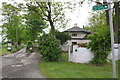
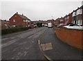
North Lodge and bridleway from Wakefield Road
Image: © Roger Templeman
Taken: 30 May 2013
0.07 miles