IMAGES TAKEN NEAR TO
Ingthorns Road, LEEDS, LS25 5PP
Introduction
This page details the photographs taken nearby to Ingthorns Road, LS25 5PP by members of the Geograph project.
The Geograph project started in 2005 with the aim of publishing, organising and preserving representative images for every square kilometre of Great Britain, Ireland and the Isle of Man.

There are currently over 7.5m images from over14,400 individuals and you can help contribute to the project by visiting https://www.geograph.org.uk
Image Map (Loading...)


Getting Data...Please wait
Leaflet Map data © OpenStreetMap
Images are licensed for reuse under creativecommons.org/licenses/by-sa/2.0
Notes
- Clicking on the map will re-center to the selected point.
- The higher the marker number, the further away the image location is from the centre of the postcode.
Image Listing (20 Images Found)
Images are licensed for reuse under creativecommons.org/licenses/by-sa/2.0
Image
Details
Distance
1
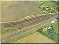
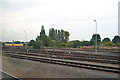
Sidings Between South Milford and Monk Fryston
Aerial view, interesting patterns.
Image: © Paul Johnston-Knight
Taken: 17 Sep 2005
0.03 miles
2
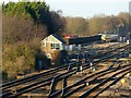
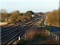
Milford Junction
Telephoto view from Lumby Lane Bridge showing the signal box and the sidings. The latter were formerly a wagon repair site when there was still extensive coal traffic in the area.
Image: © Alan Murray-Rust
Taken: 9 Dec 2019
0.06 miles
4
Sidings at South Milford junction
Opposite Brooklands
Image: © John Firth
Taken: 18 Aug 2011
0.10 miles
5
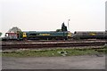
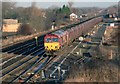
South Milford Sidings
66 544 entering South Milford sidings
Image: © Wilson Adams
Taken: 23 Apr 2003
0.12 miles
6
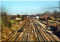
Monk Fryston Railway Junction
View of rail junction from top of road bridge at Monk Fryson.
Image: © derek dye
Taken: 7 Dec 2012
0.13 miles
7
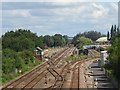
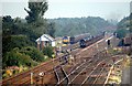
Milford (Junction) railway station (site), Yorkshire
Opened in 1840 by the York & North Midland Railway on the line from York to Castleford, this station closed in 1904 when it was replaced by Monk Fryston station (a few hundred metres behind the camera position). It was known as "Milford Junction" until 1893.
View north towards Sherburn-in-Elmet and York. The station was just beyond and to the right of the signal box, but all trace of it has apparently disappeared over the years as the area was used for sidings when this image was taken.
Image: © Nigel Thompson
Taken: 11 Jul 2020
0.19 miles
8
Milford Junction
View from Lumby Lane Bridge. This was the original York and North Midland Railway line, built 1839-40, the junction to the right being a connecting curve built at the same time onto the Leeds and Selby Railway. Both lines later formed part of the North Eastern Railway.
Image: © Alan Murray-Rust
Taken: 9 Dec 2019
0.21 miles
9
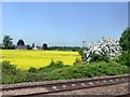
Trackside field and housing
Viewed from the passing steam-hauled Coast to Coast Express.
Image: © Graham Hogg
Taken: 19 May 2018
0.21 miles