IMAGES TAKEN NEAR TO
Old Vicarage Lane, LEEDS, LS25 5EA
Introduction
This page details the photographs taken nearby to Old Vicarage Lane, LS25 5EA by members of the Geograph project.
The Geograph project started in 2005 with the aim of publishing, organising and preserving representative images for every square kilometre of Great Britain, Ireland and the Isle of Man.

There are currently over 7.5m images from over14,400 individuals and you can help contribute to the project by visiting https://www.geograph.org.uk
Image Map
Images are licensed for reuse under creativecommons.org/licenses/by-sa/2.0
Notes
- Clicking on the map will re-center to the selected point.
- The higher the marker number, the further away the image location is from the centre of the postcode.
Image Listing (64 Images Found)
Images are licensed for reuse under creativecommons.org/licenses/by-sa/2.0
Image
Details
Distance
1
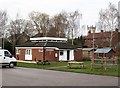
Monk Fryston Community Centre
Neat modern building next to the children's swing park.
Image: © Gordon Hatton
Taken: 17 Feb 2009
0.04 miles
2
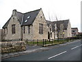
Former school, Monk Fryston
The original Victorian village school has been cleaned up and converted into houses. The new village school is just across the road.
Image: © Gordon Hatton
Taken: 17 Feb 2009
0.07 miles
3
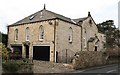
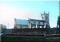
Former Methodist chapel, Monk Fryston
Built originally as a hexagonal Wesleyan chapel, it was later extended with the 'wings' seen here. Now converted for residential use.
Image: © Gordon Hatton
Taken: 17 Feb 2009
0.07 miles
4
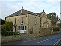
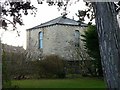
Former Wesleyan chapel, Monk Fryston
View from the south east. The chapel was built in 1845 and has been converted to residential use as 'Wesley House'. Listed Grade II.
Image: © Alan Murray-Rust
Taken: 8 Dec 2019
0.07 miles
5
Former Wesleyan chapel, Monk Fryston
The unusual angular apse at the northern end of the building. Built 1845, Listed Grade II.
Image: © Alan Murray-Rust
Taken: 8 Dec 2019
0.08 miles
6
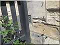
Ordnance Survey Flush Bracket S8673
This can be found on the wall of the former school, now a private dwelling, in Monk Fryston.
For more detail see : http://www.bench-marks.org.uk/bm21260
Image: © Peter Wood
Taken: 4 Aug 2014
0.08 miles
7
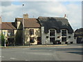
Thatched Cottage, Monk Fryston
This cottage is on the northern side of the A63, just at the gates of Monk Fryston Hall Hotel .
Image: © Bill Henderson
Taken: 20 Sep 2006
0.08 miles
8
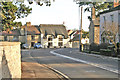
Monk Fryston Village Main Street
Image: © Gordon Kneale Brooke
Taken: 12 Jan 2006
0.08 miles
10
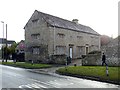
The Manor House, Monk Fryston
17th century stone house, dated 1655, Listed Grade II.
Image: © Alan Murray-Rust
Taken: 8 Dec 2019
0.09 miles