IMAGES TAKEN NEAR TO
Cliffe Houses, LEEDS, LS25 4BY
Introduction
This page details the photographs taken nearby to Cliffe Houses, LS25 4BY by members of the Geograph project.
The Geograph project started in 2005 with the aim of publishing, organising and preserving representative images for every square kilometre of Great Britain, Ireland and the Isle of Man.

There are currently over 7.5m images from over14,400 individuals and you can help contribute to the project by visiting https://www.geograph.org.uk
Image Map
Images are licensed for reuse under creativecommons.org/licenses/by-sa/2.0
Notes
- Clicking on the map will re-center to the selected point.
- The higher the marker number, the further away the image location is from the centre of the postcode.
Image Listing (25 Images Found)
Images are licensed for reuse under creativecommons.org/licenses/by-sa/2.0
Image
Details
Distance
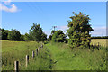
1
Houses on Pit Lane
Looking north towards Micklefield.
Image: © Stephen Craven
Taken: 6 Oct 2019
0.02 miles
2
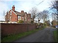
Housing along Pit Lane
1 - 3 Cliffe Villas.
Image: © Christine Johnstone
Taken: 11 Dec 2013
0.03 miles
3
![Houses along Pit Lane [1]](https://s1.geograph.org.uk/geophotos/03/77/63/3776345_ae8e8830_120x120.jpg)
Houses along Pit Lane [1]
Cliffe Bungalows and Warren Farm Cottages.
Image: © Christine Johnstone
Taken: 11 Dec 2013
0.04 miles
5
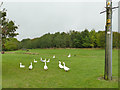
Geese in a field by Pit Lane
They remained perfectly still as I photographed them, they could have been posing.
Image: © Stephen Craven
Taken: 6 Oct 2019
0.05 miles
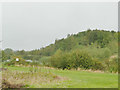
6
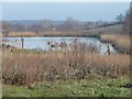
Pond to the east of Pit Lane
With a former colliery to the west and a working quarry to the south, this probably has something to do with draining post-industrial sites.
Image: © Christine Johnstone
Taken: 11 Dec 2013
0.06 miles
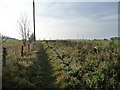
7
Pit Lane, Micklefield
The lane is now a public bridleway beyond this point.
Image: © Stephen Craven
Taken: 6 Oct 2019
0.06 miles
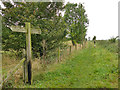
8
Upper Peckfield / Pit Lane
A public bridleway signposted as Upper Peckfield Lane but mapped as Pit Lane.
Image: © Christine Johnstone
Taken: 11 Dec 2013
0.08 miles
9
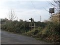
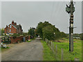
Public footpath signpost, Pit Lane
Where a footpath runs west from the bridleway, towards the Roman Ridge Road [A656].
Image: © Christine Johnstone
Taken: 11 Dec 2013
0.09 miles
10
Upper Peckfield Lane
Signposted as Upper Peckfield Lane, which heads south to the A63.
Image: © Chris Heaton
Taken: 11 Jul 2020
0.10 miles