IMAGES TAKEN NEAR TO
Isabella Road, LEEDS, LS25 2DY
Introduction
This page details the photographs taken nearby to Isabella Road, LS25 2DY by members of the Geograph project.
The Geograph project started in 2005 with the aim of publishing, organising and preserving representative images for every square kilometre of Great Britain, Ireland and the Isle of Man.

There are currently over 7.5m images from over14,400 individuals and you can help contribute to the project by visiting https://www.geograph.org.uk
Image Map
Images are licensed for reuse under creativecommons.org/licenses/by-sa/2.0
Notes
- Clicking on the map will re-center to the selected point.
- The higher the marker number, the further away the image location is from the centre of the postcode.
Image Listing (27 Images Found)
Images are licensed for reuse under creativecommons.org/licenses/by-sa/2.0
Image
Details
Distance
1
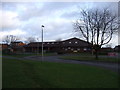
A642 Roundabout
A642 roundabout with Brierlands Close and Isabella Road. Construction is currently going on on the industrial estate in the background.
Image: © Darren Haddock
Taken: 11 Sep 2006
0.05 miles
3

Footpath junction off Ash Lane, Garforth
The collieries and their railway line have given way to industrial sheds and fenced footpaths.
Image: © Christine Johnstone
Taken: 27 Mar 2015
0.12 miles
4
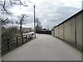
The former Aberford Railway entering Garforth
Now a public footpath and access road for local companies.
Image: © Christine Johnstone
Taken: 27 Mar 2015
0.12 miles
5
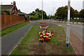
Small Floral Display on the A642, North East Garforth
The flowers are pretty, but the grass needs a little attention
Image: © Chris Heaton
Taken: 22 Sep 2018
0.13 miles
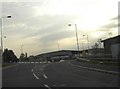
6
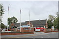
Aagrah Restaurant, Garforth
Indian Restaurant on the A642 in East Garforth
Image: © Chris Heaton
Taken: 22 Sep 2018
0.14 miles
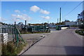
7
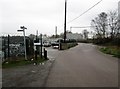
Industrial units Ash Lane Garforth
Also a footpath junction we are going left
Image: © Martin Dawes
Taken: 29 Mar 2017
0.14 miles
8
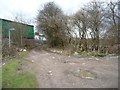
Three-way footpath junction at Garforth's edge
The green shed is located between Ash Lane and Lotherton Way.
Image: © Christine Johnstone
Taken: 27 Mar 2015
0.15 miles