IMAGES TAKEN NEAR TO
Street 1, WETHERBY, LS23 7FW
Introduction
This page details the photographs taken nearby to Street 1, LS23 7FW by members of the Geograph project.
The Geograph project started in 2005 with the aim of publishing, organising and preserving representative images for every square kilometre of Great Britain, Ireland and the Isle of Man.

There are currently over 7.5m images from over14,400 individuals and you can help contribute to the project by visiting https://www.geograph.org.uk
Image Map
Images are licensed for reuse under creativecommons.org/licenses/by-sa/2.0
Notes
- Clicking on the map will re-center to the selected point.
- The higher the marker number, the further away the image location is from the centre of the postcode.
Image Listing (41 Images Found)
Images are licensed for reuse under creativecommons.org/licenses/by-sa/2.0
Image
Details
Distance
1
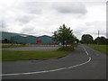
Thorp Arch estate
The Thorp Arch trading estate is built on a former Royal Ordnance Factory (ROF). This site produced munitions for WWII and the Korean war. Now this area is a trading estate housing a selection of industrial and commercial units.
Image: © DS Pugh
Taken: 7 Jul 2007
0.03 miles
2
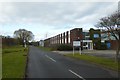
Unit 760 on Street 1
Looking towards an event prop hire business occupying unit 760 on Street 1 at Thorp Arch.
Image: © DS Pugh
Taken: 26 Nov 2017
0.03 miles

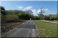
4
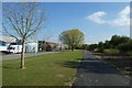
New path beside Street 1
Looking along a new link of path between Thorp Arch and Wharfe Bridge. This completes the path linking Spofforth - Wetherby - Thorp Arch - Newton Kyme.
Image: © DS Pugh
Taken: 11 Apr 2020
0.05 miles
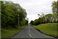
5
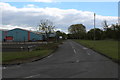
Street 1, Thorp Arch Trading Estate
One of several roads forming a grid system around industrial units.
Image: © Chris Heaton
Taken: 28 Apr 2017
0.06 miles
6
Path in Thorp Arch
Looking along a new link of path between Thorp Arch and Wharfe Bridge. This completes the path linking Spofforth - Wetherby - Thorp Arch - Newton Kyme.
Image: © DS Pugh
Taken: 11 Apr 2020
0.08 miles
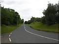
7
Avenue D, Thorp Arch Trading Estate
Route on the large industrial estate at Thorp Arch, - forming part of a grid system.
Image: © Chris Heaton
Taken: 28 Apr 2017
0.09 miles
8
Thorp Arch trading estate
The Thorp Arch trading estate is built on a former Royal Ordnance Factory (ROF). This site produced munitions for WWII and the Korean war. Here the Harland Way cycle route enters the estate from a recent extension from Walton Gates.
Image: © DS Pugh
Taken: 7 Jul 2007
0.09 miles

10
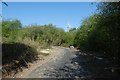
Path to Thorp Arch
Looking along a new link of path between Thorp Arch and Wharfe Bridge. This completes the path linking Spofforth - Wetherby - Thorp Arch - Newton Kyme.
Image: © DS Pugh
Taken: 11 Apr 2020
0.10 miles