IMAGES TAKEN NEAR TO
Bowcliffe Hall Estate, WETHERBY, LS23 6UN
Introduction
This page details the photographs taken nearby to Bowcliffe Hall Estate, LS23 6UN by members of the Geograph project.
The Geograph project started in 2005 with the aim of publishing, organising and preserving representative images for every square kilometre of Great Britain, Ireland and the Isle of Man.

There are currently over 7.5m images from over14,400 individuals and you can help contribute to the project by visiting https://www.geograph.org.uk
Image Map
Images are licensed for reuse under creativecommons.org/licenses/by-sa/2.0
Notes
- Clicking on the map will re-center to the selected point.
- The higher the marker number, the further away the image location is from the centre of the postcode.
Image Listing (35 Images Found)
Images are licensed for reuse under creativecommons.org/licenses/by-sa/2.0
Image
Details
Distance

3
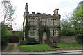
Entrance to Bowcliffe Hall
The hall itself, a corner of which can be seen to the left, is grade II listed and dates from c.1805. The entrance is relatively modern, a result of road realignment when the A1(M) was built. It also gives access to Bramham Hall.
Image: © Stephen Craven
Taken: 29 Oct 2024
0.04 miles
4
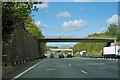
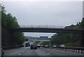
A1(M) - bridge, Brabham
The bridge gives private access to Bowcliffe Hall and some other premises. It also is used by a public footpath.
Image: © Robin Webster
Taken: 7 Oct 2011
0.04 miles
6
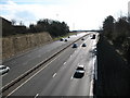
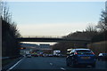
A1 - looking south
Although it is a 6 lane highway at this point, the A1 is not currently of motorway standard, although this section between Wetherby and the A64 is currently being upgraded.
Image: © Gordon Hatton
Taken: 9 Mar 2008
0.05 miles
7
The Fox Inn
O.S. 1st edition shows a T-plan church here, indicated as 'R.C. Chapel'. This building, built in 1847, is named St. Mary's on the O.S. map of 1910 though it is now dedicated to St. Brigid http://www.rathkennyparish.ie/index.php/masses/grangegeeth .
Image: © David Rogers
Taken: 28 Apr 2010
0.06 miles
8
A Halloween House
This is actually called Old Fox Cottage, but on October 31st it makes a suitably creepy subject for a Halloween photo. The 'fox' in the name is a link to the Lane-Fox family at nearby Bramham Park and this is an early 19thC lodge cottage for the estate. It stands close by a corner of one of the approach roads to the estate, but is now cut off by the nearby six lanes of roaring traffic on the A1 Motorway. To the left is a road junction [off picture] which was the old Great North Road, now reduced to an unclassified county road. The cottage is Grade II listed.
Image: © Gordon Hatton
Taken: 31 Oct 2022
0.06 miles
9
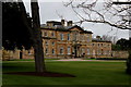
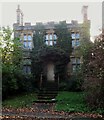
Bowcliffe Hall
Currently this stately home is used as a wedding, conference and business centre venue.
It began life in 1805, passing into the nearby Bramham Park estate in 1841 - this was due to a fire which compelled the Fox family to purchase and move in here from Bramham Hall.
1906 saw the Fox family moving back into Bramham Park, leaving Bowcliffe Hall empty.
The most notable owner since, was Robert Blackburn - an aviation pioneer.
Today it is the headquarters of the Bayford Group, amongst other organisations with offices here.
Image: © Chris Heaton
Taken: 26 Feb 2017
0.07 miles