IMAGES TAKEN NEAR TO
Castle Grove, WETHERBY, LS22 7UB
Introduction
This page details the photographs taken nearby to Castle Grove, LS22 7UB by members of the Geograph project.
The Geograph project started in 2005 with the aim of publishing, organising and preserving representative images for every square kilometre of Great Britain, Ireland and the Isle of Man.

There are currently over 7.5m images from over14,400 individuals and you can help contribute to the project by visiting https://www.geograph.org.uk
Image Map
Images are licensed for reuse under creativecommons.org/licenses/by-sa/2.0
Notes
- Clicking on the map will re-center to the selected point.
- The higher the marker number, the further away the image location is from the centre of the postcode.
Image Listing (21 Images Found)
Images are licensed for reuse under creativecommons.org/licenses/by-sa/2.0
Image
Details
Distance
1
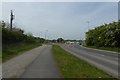
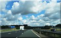
Sandbeck Lane roundabout
Looking along the A168 as it approaches Sandbeck Lane.
Image: © DS Pugh
Taken: 30 Apr 2017
0.05 miles
2
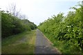
Old A1
Looking along a cycle path beside the A168 which was the A1 before the new A1(M) Wetherby section was constructed.
Image: © DS Pugh
Taken: 30 Apr 2017
0.07 miles
3
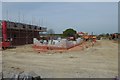
Building work beside Sandbeck Lane
Looking over a construction site next to the A168 and Sandbeck Lane roundabout.
Image: © DS Pugh
Taken: 30 Apr 2017
0.07 miles
4
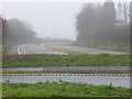
End of the road
Now that the A1(M) has been opened north of Wetherby, this sweep of the A1 trunk road is disused. In the foreground is the Sandbeck Lane roundabout.
Image: © Roger W Haworth
Taken: 28 Dec 2006
0.12 miles

7
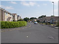
Otterwood Bank - viewed from Foxwood Walk
Image: © Betty Longbottom
Taken: 20 Jul 2016
0.16 miles
9
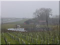
Pond near Sandbeck House
This pond may have been created because the construction of the start of the A1(M) north of Wetherby had destroyed the natural drainage from this point.
Image: © Roger W Haworth
Taken: 28 Dec 2006
0.17 miles
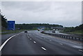
10
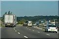
Wetherby : A1(M)
Looking north on the A1(M).
Image: © Lewis Clarke
Taken: 21 Sep 2020
0.17 miles