IMAGES TAKEN NEAR TO
Coxwold View, WETHERBY, LS22 7PU
Introduction
This page details the photographs taken nearby to Coxwold View, LS22 7PU by members of the Geograph project.
The Geograph project started in 2005 with the aim of publishing, organising and preserving representative images for every square kilometre of Great Britain, Ireland and the Isle of Man.

There are currently over 7.5m images from over14,400 individuals and you can help contribute to the project by visiting https://www.geograph.org.uk
Image Map
Images are licensed for reuse under creativecommons.org/licenses/by-sa/2.0
Notes
- Clicking on the map will re-center to the selected point.
- The higher the marker number, the further away the image location is from the centre of the postcode.
Image Listing (137 Images Found)
Images are licensed for reuse under creativecommons.org/licenses/by-sa/2.0
Image
Details
Distance
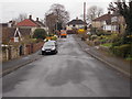
1
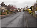
Coxwold View - looking towards Barleyfields Road
Image: © Betty Longbottom
Taken: 5 Apr 2016
0.03 miles
3
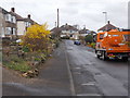
Coxwold View - looking towards Coxwold Hill
Image: © Betty Longbottom
Taken: 5 Apr 2016
0.04 miles
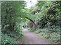
6
Harland Way - viewed from Barleyfields Road Bridge
Image: © Betty Longbottom
Taken: 5 Apr 2016
0.06 miles
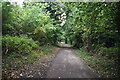
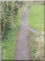
7
Former railway path, Wetherby
A path along the route of a dismantled railway in Wetherby, in West Yorkshire. The railway closed in 1964. The path is shared by walkers and cyclists, and forms part of route 67 of the National Cycle Network.
Image: © Malc McDonald
Taken: 14 Oct 2021
0.06 miles
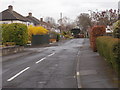

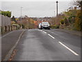
10
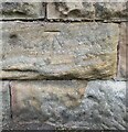
Wetherby, Barleyfields Road bridge
The benchmark is cut into the 2nd course of stone on the west parapet. The bridge is over the disused railway line.
Image: © Mel Towler
Taken: 19 Sep 2022
0.07 miles