IMAGES TAKEN NEAR TO
School Lane, WETHERBY, LS22 5BQ
Introduction
This page details the photographs taken nearby to School Lane, LS22 5BQ by members of the Geograph project.
The Geograph project started in 2005 with the aim of publishing, organising and preserving representative images for every square kilometre of Great Britain, Ireland and the Isle of Man.

There are currently over 7.5m images from over14,400 individuals and you can help contribute to the project by visiting https://www.geograph.org.uk
Image Map
Images are licensed for reuse under creativecommons.org/licenses/by-sa/2.0
Notes
- Clicking on the map will re-center to the selected point.
- The higher the marker number, the further away the image location is from the centre of the postcode.
Image Listing (137 Images Found)
Images are licensed for reuse under creativecommons.org/licenses/by-sa/2.0
Image
Details
Distance
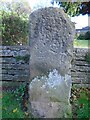
4
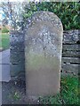
Old milestone
The third old milestone at the east end of Collingham Village Hall has no discernible legend except TO, although there may be an H and D below that signifying it was once on the road to Harewood, A659. An older image from 2005 can be seen at Image
Image: © Chris Minto
Taken: 21 Nov 2021
0.04 miles
5
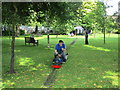
Miniature railway, Collingham Gala
A temporary attraction.
Image: © Jonathan Thacker
Taken: 22 Jun 2014
0.04 miles
6
Old milestone
On a path leading north off the A58 at the east side of Collingham Village Hall there are 3 old wayside stones. This is the one nearest the main road. A clear inscription, TO/HAREWOOD/5 MILES & TO/TADCASTER/8 MILES with pointing hands. This stone may have been near the current junction of the A659 leading off the A58.
Image: © Chris Minto
Taken: 21 Nov 2021
0.04 miles
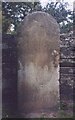
7
Old milestone
The second of the three stones on the path at the east end of Collingham Village Hall is triangular. More damaged and eroded than the stone nearest the A58 road, most of the legend on this face, LEEDS/8/MILES, can be discerned. This stone also shows some of the rough base which would have been under soil level. It was probably sited near SE 369 430 where a WRCC post was erected in 1893/94 but which is now missing.
Image: © Chris Minto
Taken: 21 Nov 2021
0.04 miles
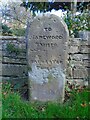
9
Old Milestone, A659, Harewood Road
The third old milestone at the east end of Collingham Village Hall along a Public Right of Way by the entrance to a public garden/open space. Most likely it was once on the road to Harewood, A659 at SE 38293 45891.
A modern image can be seen at Image Erected by Tadcaster & Otley turnpike trust, 19th century.
Inscription: To / H(arewoo )D / (5 / Tadcaster / 7)
Milestone Society National ID: YW_XCOLc
Image: © Christine Minto
Taken: 21 Dec 2005
0.04 miles
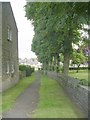
10

Old Guide Stone off the A58, Collingham, East Keswick parish
Stone post by the public footpath off the A58, in parish of East Keswick (Leeds District); it was where there is a current B&B stone at East Keswick, now East of junction with A659 to Harewood, alongside public footpath, behind bus stop, opposite village hall. For a later photo see Image
Out of place - in public view
Inscription reads:-
TO
HAREWOOD
3 MILES
{<-hand}
TADCASTER
8 MILES
{hand->}
Milestone Society National ID: YW_XCOLa
Image: © Milestone Society
Taken: Unknown
0.04 miles