IMAGES TAKEN NEAR TO
School House Terrace, WETHERBY, LS22 4EH
Introduction
This page details the photographs taken nearby to School House Terrace, LS22 4EH by members of the Geograph project.
The Geograph project started in 2005 with the aim of publishing, organising and preserving representative images for every square kilometre of Great Britain, Ireland and the Isle of Man.

There are currently over 7.5m images from over14,400 individuals and you can help contribute to the project by visiting https://www.geograph.org.uk
Image Map
Images are licensed for reuse under creativecommons.org/licenses/by-sa/2.0
Notes
- Clicking on the map will re-center to the selected point.
- The higher the marker number, the further away the image location is from the centre of the postcode.
Image Listing (25 Images Found)
Images are licensed for reuse under creativecommons.org/licenses/by-sa/2.0
Image
Details
Distance
2
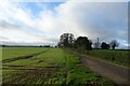
Track to Woodlands Farm
A farm off Knaresborough Road, the B6164.
Image: © DS Pugh
Taken: 28 Dec 2024
0.08 miles
3
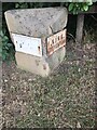
Old Boundary Marker on the B6164 Knaresborough Road
Parish Boundary Marker on the northeast side of the B6164 Knaresborough Road opposite Woodlands Farm and beside village entry sign. On the boundary of Kirk Deighton and North Deighton. NORTH / DEIGHTON and KIRK / DEIGHTON in raised lettering on plates on adjacent faces of the stone. Formerly a township in Kirk Deighton parish, North Deighton was made a separate parish in 1866 and the stone probably dates from then.
Milestone Society National ID: YW_KDENDE01pb
Image: © P Robertson
Taken: 24 Sep 2021
0.09 miles
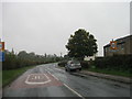
4
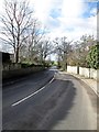
The B6164 Knaresborough Road leaving Kirk Deighton
Toward North Deighton
Image: © Martin Dawes
Taken: 20 Feb 2018
0.11 miles
5
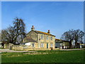
Woodlands Farm
Farmhouse near Kirk Deighton - reached by a public footpath from the B6164
Image: © Chris Heaton
Taken: 14 Mar 2014
0.14 miles
6
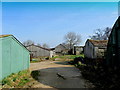
Outbuildings behind Woodlands Farm
Mostly chicken battery huts - nearly all these buildings appear to have been abandoned.
Image: © Chris Heaton
Taken: 14 Mar 2014
0.18 miles
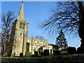
7
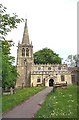
Kirk Deighton, All saints Church
This Church is central in the eastern quarter of the O/S grid it occupies. It is situated on the east side of the B6164 Wetherby to Knaresborough Road.
Image: © Bill Henderson
Taken: Unknown
0.21 miles
8
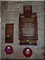
All Saints Church, Kirk Deighton, War Memorial
Image: © Alexander P Kapp
Taken: 13 May 2010
0.22 miles
9
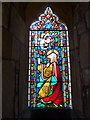
All Saints Church, Kirk Deighton, Stained glass window
Image: © Alexander P Kapp
Taken: 13 May 2010
0.22 miles