IMAGES TAKEN NEAR TO
Otley Road, OTLEY, LS21 3DP
Introduction
This page details the photographs taken nearby to Otley Road, LS21 3DP by members of the Geograph project.
The Geograph project started in 2005 with the aim of publishing, organising and preserving representative images for every square kilometre of Great Britain, Ireland and the Isle of Man.

There are currently over 7.5m images from over14,400 individuals and you can help contribute to the project by visiting https://www.geograph.org.uk
Image Map
Images are licensed for reuse under creativecommons.org/licenses/by-sa/2.0
Notes
- Clicking on the map will re-center to the selected point.
- The higher the marker number, the further away the image location is from the centre of the postcode.
Image Listing (27 Images Found)
Images are licensed for reuse under creativecommons.org/licenses/by-sa/2.0
Image
Details
Distance
1
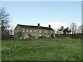
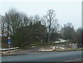
Green Gate Farm
A farmhouse near Burley-in-Wharfedale, with a former barn adjoining to its left that has been converted to residential use. Both parts of the building are grade II listed (farmhouse - entry 1314213; barn - 1200763).
Image: © Stephen Craven
Taken: 22 Nov 2020
0.01 miles
2
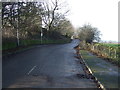
Otley Road near Laund House Farm
Looking west.
Image: © JThomas
Taken: 17 Dec 2016
0.02 miles
3
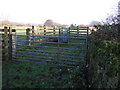
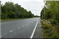
Otley Road at Green Gate Farm
This is the old road to Otley, now bypassed by a modern A-road. After a short distance as a tarmac surfaced road, it becomes a bridleway.
Image: © Stephen Craven
Taken: 22 Nov 2020
0.03 miles
4
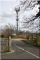
Communications Mast
On the former A660 near to Laund House Farm
Image: © John Sparshatt
Taken: 4 Apr 2008
0.04 miles
5
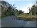
Otley Road (formerly the A660) off the new route of the A660
Image: © Alexander P Kapp
Taken: 16 Jan 2013
0.05 miles
7
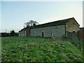
Laund House Farm
A farmhouse near Burley-in-Wharfedale. This is the rear of the building, seen from a public footpath.
Image: © Stephen Craven
Taken: 22 Nov 2020
0.05 miles
9
Former route of A660 near Burley
Complete with original road markings and catseye studs, this bridleway was the old narrow version of the main A660 road from Ilkley to Leeds. Seen near the Orange cellphone mast looking westwards. The replacement road is a single carriageway that boldly goes across the Wharfe's floodplain.
Image: © David Spencer
Taken: 4 Sep 2005
0.08 miles