IMAGES TAKEN NEAR TO
West Chevin Road, OTLEY, LS21 3DJ
Introduction
This page details the photographs taken nearby to West Chevin Road, LS21 3DJ by members of the Geograph project.
The Geograph project started in 2005 with the aim of publishing, organising and preserving representative images for every square kilometre of Great Britain, Ireland and the Isle of Man.

There are currently over 7.5m images from over14,400 individuals and you can help contribute to the project by visiting https://www.geograph.org.uk
Image Map (Loading...)


Getting Data...Please wait
Leaflet Map data © OpenStreetMap
Images are licensed for reuse under creativecommons.org/licenses/by-sa/2.0
Notes
- Clicking on the map will re-center to the selected point.
- The higher the marker number, the further away the image location is from the centre of the postcode.
Image Listing (18 Images Found)
Images are licensed for reuse under creativecommons.org/licenses/by-sa/2.0
Image
Details
Distance
1
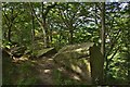
Crags in Ackroyd's Wood, near Otley
Rock outcrop at the western end of the Chevin Forest Park
Image: © Paul Harrop
Taken: 29 Jun 2015
0.17 miles
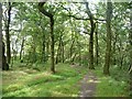
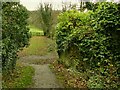
2
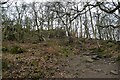
Overhanging rocks in the woods
Looking along a path up the Chevin.
Image: © DS Pugh
Taken: 2 Apr 2021
0.19 miles
3
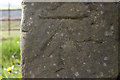
Cut Bench Mark, West Chevin Road
Bench Mark Database: http://www.bench-marks.org.uk/bm48348
Image: © Mark Anderson
Taken: 1 May 2013
0.19 miles

5
Crag in Great Dib wood
This crag is hidden in the wooded hillside where a footpath descends northwards from Yorkgate to the western end of Otley.
Image: © David Spencer
Taken: 21 Aug 2005
0.19 miles
6
Former railway route, looking towards Otley
This was the Ilkley to Bramhope railway line that closed to passengers in 1965.
Image: © Stephen Craven
Taken: 22 Nov 2020
0.20 miles
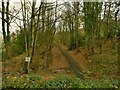
7
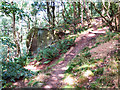
Path in Wilson's Wood, Otley
Part of the Chevin Forest Park.
Image: © Humphrey Bolton
Taken: 14 Aug 2011
0.21 miles
8
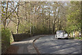
Vintage Car driving up West Chevin Road
There is a cut bench mark on the gatepost to the left of the photograph and a closer view can be seen here: Image
Image: © Mark Anderson
Taken: 1 May 2013
0.21 miles
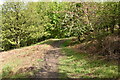
10
Old bridge abutments
The path that now joins the former route of the Bramhope to Ilkley railway line once crossed the railway by a footbridge, of which only these stone abutments remain.
Image: © Stephen Craven
Taken: 22 Nov 2020
0.21 miles