IMAGES TAKEN NEAR TO
York Gate, OTLEY, LS21 3DG
Introduction
This page details the photographs taken nearby to York Gate, LS21 3DG by members of the Geograph project.
The Geograph project started in 2005 with the aim of publishing, organising and preserving representative images for every square kilometre of Great Britain, Ireland and the Isle of Man.

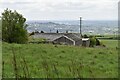
There are currently over 7.5m images from over14,400 individuals and you can help contribute to the project by visiting https://www.geograph.org.uk
Image Map
Images are licensed for reuse under creativecommons.org/licenses/by-sa/2.0
Notes
- Clicking on the map will re-center to the selected point.
- The higher the marker number, the further away the image location is from the centre of the postcode.
Image Listing (95 Images Found)
Images are licensed for reuse under creativecommons.org/licenses/by-sa/2.0
Image
Details
Distance
2
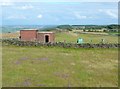
Bunker on Otley Chevin, Guiseley
I think this is one of the Royal Observer Corps bunkers, constructed to monitor radiation levels during the 'Cold War' in the second half of the 20C. Interesting that heather is re-establishing itself in the pasture (in the foreground).
Image: © Humphrey Bolton
Taken: 14 Aug 2011
0.02 miles
3
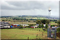
Leeds Bradford Airport Beacon
One of the outer marker beacons for Leeds Bradford Airport marks the highest ground on Otley Chevin.
Image: © Tom Blackwell
Taken: 4 Feb 2009
0.05 miles
4
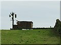
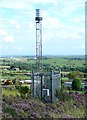
Telecoms installation on Otley Chevin
Situated at almost the highest point of the Chevin ridge (around 280m AOD), the dishes have been added to the former military bunker Image since 2011. This does suggest it may be a military installation, although in that case I would expect greater security.
Image: © Stephen Craven
Taken: 16 Dec 2018
0.06 miles
5
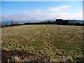
Farmland north of Beacon House Farm
Just south of the Otley Chevin escarpment.
Image: © Christine Johnstone
Taken: 11 Mar 2014
0.06 miles
6
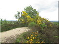
Beacon Hill, The Chevin
Probable summit.
Image: © Richard Webb
Taken: 22 May 2022
0.07 miles
7
Beacon Hill, The Chevin
One of the summit candidates.
Image: © Richard Webb
Taken: 22 May 2022
0.07 miles
8
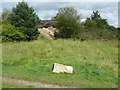
Sloping rock in Yorkgate Quarry, Guiseley
A car park for the Chevin Forest Park has been made in a disused quarry. A footpath leads from it to Wilson's Wood, and one of the features alongside it is a large sloping slab of millstone grit. The stone in the foreground is a marker for a geological trail.
Image: © Humphrey Bolton
Taken: 14 Aug 2011
0.08 miles
9
Beacon for Leeds-Bradford Airport, Guiseley
Image: © Humphrey Bolton
Taken: 14 Aug 2011
0.08 miles
10
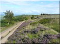
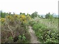
The path from Yorkgate Quarry to Surprise View, Otley
Surprise View is the group of rocks on the horizon towards the right.
Image: © Humphrey Bolton
Taken: 14 Aug 2011
0.09 miles