IMAGES TAKEN NEAR TO
Whin Park, OTLEY, LS21 1QB
Introduction
This page details the photographs taken nearby to Whin Park, LS21 1QB by members of the Geograph project.
The Geograph project started in 2005 with the aim of publishing, organising and preserving representative images for every square kilometre of Great Britain, Ireland and the Isle of Man.

There are currently over 7.5m images from over14,400 individuals and you can help contribute to the project by visiting https://www.geograph.org.uk
Image Map (Loading...)


Getting Data...Please wait
Leaflet Map data © OpenStreetMap
Images are licensed for reuse under creativecommons.org/licenses/by-sa/2.0
Notes
- Clicking on the map will re-center to the selected point.
- The higher the marker number, the further away the image location is from the centre of the postcode.
Image Listing (7 Images Found)
Images are licensed for reuse under creativecommons.org/licenses/by-sa/2.0
Image
Details
Distance
1
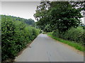
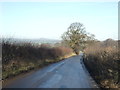
Black Hill Road
Road running south from Arthington towards Adel, in the outskirts of Leeds.
Image: © Chris Heaton
Taken: 14 Aug 2012
0.07 miles
2
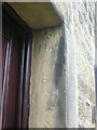
Old Guide Stone at Bank Foot Farm, Black Hill Road, Arthington
Guide Stone re-used as a door jamb at Bank Foot Farm, in parish of Arthington (Leeds District). Formerly in Arthington Lane, now at Bank Foot Farm, Black Hill Road, Arthington.
Out of place - in public view
Milestone Society National ID: YW_XARTH
Image: © Milestone Society
Taken: Unknown
0.07 miles