IMAGES TAKEN NEAR TO
Garnetts End, OTLEY, LS21 1GB
Introduction
This page details the photographs taken nearby to Garnetts End, LS21 1GB by members of the Geograph project.
The Geograph project started in 2005 with the aim of publishing, organising and preserving representative images for every square kilometre of Great Britain, Ireland and the Isle of Man.

There are currently over 7.5m images from over14,400 individuals and you can help contribute to the project by visiting https://www.geograph.org.uk
Image Map (Loading...)


Getting Data...Please wait
Leaflet Map data © OpenStreetMap
Images are licensed for reuse under creativecommons.org/licenses/by-sa/2.0
Notes
- Clicking on the map will re-center to the selected point.
- The higher the marker number, the further away the image location is from the centre of the postcode.
Image Listing (272 Images Found)
Images are licensed for reuse under creativecommons.org/licenses/by-sa/2.0
Image
Details
Distance
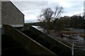
1
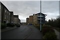
Garnetts Grove
Looking along Garnetts Grove on the banks of the River Wharfe.
Image: © DS Pugh
Taken: 28 Dec 2021
0.02 miles
2
Garnetts Mill from River Wharfe 2015
This picture shows the final remains of Garnetts Mill being demolished on Thursday 30th April 2015. Compare this shot to a photo I took in 2008 here: Image
The main building of the mill was supposed to be left standing according to the planning permission given to the builders. However, apparently the building was unsound and they demolished it anyway.
Image: © Les
Taken: 30 Apr 2015
0.02 miles
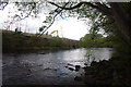
3
Old outfall from Garnett's Mill
This would have been the tailrace of the mill. Its function as a user of water power has been taken by the modern hydro-electric plant Image
Image: © Stephen Craven
Taken: 21 May 2022
0.04 miles
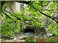
5
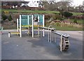
Water play, Otley
I must bring my grandson here so that I can play with this. The water is raised by an Archimedean screw, then is led to a water-wheel.
Image: © Humphrey Bolton
Taken: 17 Feb 2008
0.04 miles
6
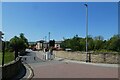
Traffic restrictions on Wharfside
Looking along Wharfside towards Buon Apps.
Image: © DS Pugh
Taken: 3 Jun 2023
0.05 miles
7

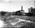
Otley weir and Garnett's paper mill
Taken when the mill was still active in late 1992 (I think). The river is a good bit higher than usual: see John Sparshatt's photo at http://www.geograph.org.uk/photo/3265333 for how it usually looks. When I was a kid, I and my brother and sister used to come and play in the river here, treating the weir like a big waterslide. I imagine social services would be called if you let your kids do such a thing these days!
Garnett's mill is now closed and the area is having hundreds of houses built on it.
Image: © John Winder
Taken: Unknown
0.06 miles
8
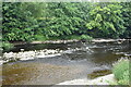
Weir, River Wharfe, Otley, Yorkshire
This huge weir was constructed many years ago to assure a water supply for the industrial premises on the further bank.
Image: © Dr Neil Clifton
Taken: 29 May 1974
0.06 miles
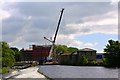
10
Garnett Wharfe Hydro
Looking along the weir with two Archimedes screw hydro-electric turbines generating electricity from the River Wharfe.
Image: © DS Pugh
Taken: 28 Dec 2021
0.06 miles