IMAGES TAKEN NEAR TO
Valley View, OTLEY, LS21 1ER
Introduction
This page details the photographs taken nearby to Valley View, LS21 1ER by members of the Geograph project.
The Geograph project started in 2005 with the aim of publishing, organising and preserving representative images for every square kilometre of Great Britain, Ireland and the Isle of Man.

There are currently over 7.5m images from over14,400 individuals and you can help contribute to the project by visiting https://www.geograph.org.uk
Image Map (Loading...)


Getting Data...Please wait
Leaflet Map data © OpenStreetMap
Images are licensed for reuse under creativecommons.org/licenses/by-sa/2.0
Notes
- Clicking on the map will re-center to the selected point.
- The higher the marker number, the further away the image location is from the centre of the postcode.
Image Listing (66 Images Found)
Images are licensed for reuse under creativecommons.org/licenses/by-sa/2.0
Image
Details
Distance
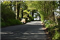
1
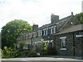
Houses on Cabin Road
The road into the woods used to serve extensive quarries, so these houses may have been built for quarry workers.
Image: © Stephen Craven
Taken: 28 Dec 2020
0.00 miles
2
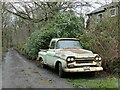
Old Chevvy on Cabin Road
An ancient Chevrolet pickup truck.
Image: © Stephen Craven
Taken: 28 Dec 2020
0.02 miles
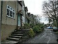
4
Footpath to Leeds Road from Old Pool Bank
Image: © Betty Longbottom
Taken: 20 Jul 2009
0.05 miles
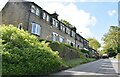
5
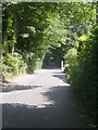
Old Pool Bank - looking down from Leeds Road
Image: © Betty Longbottom
Taken: 20 Jul 2009
0.05 miles
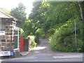
7
The Bar House, Pool Bank
A toll bar dating from the days of the turnpike road, but the question is which of these roads was the turnpike in the 18th century? The main road [A660 right] was built to replace the Old Otley Road which is further to the SW. The minor road [left] is Old Pool Bank, but was this a turnpike on the route from Dudley Hill in Bradford to Killinghall, or was the turnpike the current A658 further east? Perhaps someone out there knows the answer.
Just visible over the right hand end of the Bar House is the abutment of a bridge that once carried a tramway over the main road, linking quarries at SE233433 and SE242434 with the railway at Pool station [SE248437].
A visitor to the website has reminded me that the current A658 Bradford to Pool road was the line of the Dudley Hill and Killinhall turnpike, so this toll house at Chain Bar was on the Leeds to Skipton route.
Image: © Gordon Hatton
Taken: 27 Jan 2009
0.07 miles
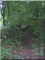
8
Old quarry north of Cabin Road
Part of the once extensive Pool Bank stone quarries. A full history of the quarries can be found at https://www.poolinwharfedalehistory.co.uk/6-pool-bank-quarries/
Image: © Stephen Craven
Taken: 28 Dec 2020
0.07 miles