IMAGES TAKEN NEAR TO
Carlton Lane, LEEDS, LS20 9NH
Introduction
This page details the photographs taken nearby to Carlton Lane, LS20 9NH by members of the Geograph project.
The Geograph project started in 2005 with the aim of publishing, organising and preserving representative images for every square kilometre of Great Britain, Ireland and the Isle of Man.

There are currently over 7.5m images from over14,400 individuals and you can help contribute to the project by visiting https://www.geograph.org.uk
Image Map (22 Images)


Getting Data...Please wait
Leaflet Map data © OpenStreetMap
Images are licensed for reuse under creativecommons.org/licenses/by-sa/2.0
Notes
- Clicking on the map will re-center to the selected point.
- The higher the marker number, the further away the image location is from the centre of the postcode.
Image Listing (22 Images Found)
Images are licensed for reuse under creativecommons.org/licenses/by-sa/2.0
Image
Details
Distance
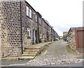
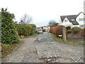
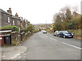
2
Carlton Drive - looking towards Carlton Lane
Image: © Betty Longbottom
Taken: 13 Nov 2012
0.07 miles
5
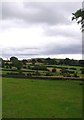
Wills Gill, Guiseley
Looking across Wills Gill fields to Yeadon Haw, from Carlton Lane
Image: © Jennifer Kirkby
Taken: 21 Aug 2015
0.11 miles
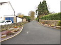
6
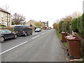
Moor Lane - viewed from Moorland Crescent
Image: © Betty Longbottom
Taken: 13 Nov 2012
0.12 miles
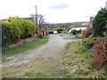
7
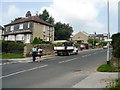
Guiseley, Corner of Kingfield and Moor Lane
Guiseley, Corner of Kingfield and Moor Lane looking Northwest
Image: © John M Wheatley
Taken: 15 Aug 2010
0.13 miles
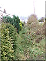
8
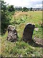
Stone Stile, Wills Gill
Squeeze Stile, Wills Gill, Guiseley; the wall has now gone.
Image: © Jennifer Kirkby
Taken: 15 Aug 2015
0.13 miles
9
Moor Lane - viewed from Moorland Crescent
Image: © Betty Longbottom
Taken: 13 Nov 2012
0.13 miles