IMAGES TAKEN NEAR TO
West Parade, LEEDS, LS20 9EU
Introduction
This page details the photographs taken nearby to West Parade, LS20 9EU by members of the Geograph project.
The Geograph project started in 2005 with the aim of publishing, organising and preserving representative images for every square kilometre of Great Britain, Ireland and the Isle of Man.

There are currently over 7.5m images from over14,400 individuals and you can help contribute to the project by visiting https://www.geograph.org.uk
Image Map (Loading...)


Getting Data...Please wait
Leaflet Map data © OpenStreetMap
Images are licensed for reuse under creativecommons.org/licenses/by-sa/2.0
Notes
- Clicking on the map will re-center to the selected point.
- The higher the marker number, the further away the image location is from the centre of the postcode.
Image Listing (264 Images Found)
Images are licensed for reuse under creativecommons.org/licenses/by-sa/2.0
Image
Details
Distance
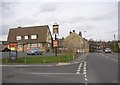
2
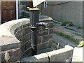
The Old Water Pump, Town Street Guiseley
Image: © John M Wheatley
Taken: 21 Jul 2008
0.03 miles
4
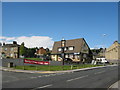
The Drop Public House, Town Street
Image: © Stephen Armstrong
Taken: 10 Sep 2010
0.03 miles
5
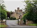
Frank Parkinson Homes, Guiseley
A set of almshouses, built in the late 20th century but in a traditional courtyard style. They are named after Frank Parkinson (1887-1946), an electrical engineer and philanthropist who was a major benefactor of the University of Leeds and founded what became Crompton Parkinson, a major employer in Guiseley until recent times. He left a bequest for these almshouses which are now managed by the Anchor Housing Association.
Image: © Stephen Craven
Taken: 22 May 2022
0.04 miles
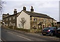
6
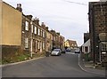
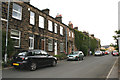
West Parade, off Lands Lane, Guiseley
A short street between Lands Lane and Town Street. The Last Drop is in the distance.
Image: © Humphrey Bolton
Taken: 15 Feb 2007
0.04 miles
9
The Drop (Inn) and Town Street, Guiseley
The 1908 map shows many tiny cottages on this site; no doubt they were demolished during the slum clearances around the 1970s.
Image: © Humphrey Bolton
Taken: 15 Feb 2007
0.04 miles
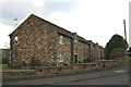
10
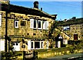
Upper End Farm House, Town Street, Guiseley
Another of the farmhouses in the row of tofts along the eastern side of Town Street.
Image: © Humphrey Bolton
Taken: 15 Feb 2007
0.05 miles