IMAGES TAKEN NEAR TO
Low Lane, LEEDS, LS18 5ST
Introduction
This page details the photographs taken nearby to Low Lane, LS18 5ST by members of the Geograph project.
The Geograph project started in 2005 with the aim of publishing, organising and preserving representative images for every square kilometre of Great Britain, Ireland and the Isle of Man.

There are currently over 7.5m images from over14,400 individuals and you can help contribute to the project by visiting https://www.geograph.org.uk
Image Map
Images are licensed for reuse under creativecommons.org/licenses/by-sa/2.0
Notes
- Clicking on the map will re-center to the selected point.
- The higher the marker number, the further away the image location is from the centre of the postcode.
Image Listing (216 Images Found)
Images are licensed for reuse under creativecommons.org/licenses/by-sa/2.0
Image
Details
Distance
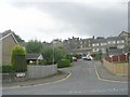
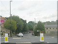
2
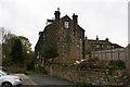
Bachelor Lane - viewed from Low Lane
Image: © Betty Longbottom
Taken: 19 Aug 2011
0.01 miles
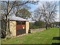
3
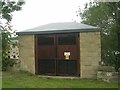
Electricity Substation No 49738 - Low Lane
Image: © Betty Longbottom
Taken: 19 Aug 2011
0.01 miles
5
Lister Hill - viewed from Low Lane
Image: © Betty Longbottom
Taken: 19 Aug 2011
0.02 miles
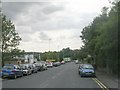
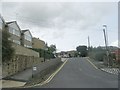
6
Substation, Low Lane, Horsforth
Quite a recent looking installation.
Image: © Stephen Craven
Taken: 8 May 2016
0.02 miles
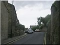
7
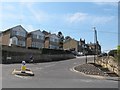
Lister Hill, Horsforth
Hard work for a lone cyclist.
Image: © Stephen Craven
Taken: 8 May 2016
0.02 miles
8
Horsforth: Houses visible from the footpath leading from Lister Hill to Long Row
Image: © Dr Neil Clifton
Taken: 14 Apr 2011
0.04 miles
9
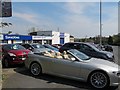
Ssang Yong, Low Lane, Horsforth
A car showroom.
Image: © Stephen Craven
Taken: 8 May 2016
0.04 miles