IMAGES TAKEN NEAR TO
Scotland Lane, LEEDS, LS18 5SF
Introduction
This page details the photographs taken nearby to Scotland Lane, LS18 5SF by members of the Geograph project.
The Geograph project started in 2005 with the aim of publishing, organising and preserving representative images for every square kilometre of Great Britain, Ireland and the Isle of Man.

There are currently over 7.5m images from over14,400 individuals and you can help contribute to the project by visiting https://www.geograph.org.uk
Image Map
Images are licensed for reuse under creativecommons.org/licenses/by-sa/2.0
Notes
- Clicking on the map will re-center to the selected point.
- The higher the marker number, the further away the image location is from the centre of the postcode.
Image Listing (33 Images Found)
Images are licensed for reuse under creativecommons.org/licenses/by-sa/2.0
Image
Details
Distance
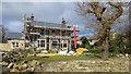
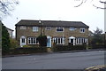
3
Entrance to 'Lomond' at Brownberrie Lane/Scotland Lane junction
Image: © Roger Templeman
Taken: 4 Feb 2023
0.09 miles
4
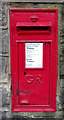
George V postbox on Brownberrie Lane, Horsforth
Postbox No. LS18 116.
Image: © JThomas
Taken: 23 Nov 2018
0.10 miles
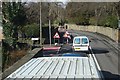
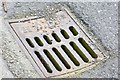
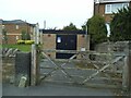
7
Point no entry, Westbrook Lane, Horsforth
Traffic heading out onto the main road (Brownberrie Lane) has to go the long way round via St Margaret's Road. Unusually for a student area there is no exception for bicycles.
Image: © Stephen Craven
Taken: 22 Sep 2020
0.12 miles
8
Montfort House, #27 on SW side of Brownberrie Lane
Image: © Luke Shaw
Taken: 4 Feb 2023
0.12 miles
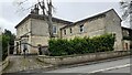
9
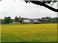
North Ives Farm, Horsforth
If there was ever a South Ives farm, it must have been swallowed up by streets and houses.
Image: © Rich Tea
Taken: 7 Jun 2008
0.12 miles
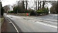
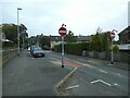
10
Gas installation, Westbrook Lane, Horsforth
In case the purpose of this facility was unclear, the concrete 'Gas' marker on the pavement gives a clue.
Image: © Stephen Craven
Taken: 22 Sep 2020
0.13 miles