IMAGES TAKEN NEAR TO
Low Lane, LEEDS, LS18 5PU
Introduction
This page details the photographs taken nearby to Low Lane, LS18 5PU by members of the Geograph project.
The Geograph project started in 2005 with the aim of publishing, organising and preserving representative images for every square kilometre of Great Britain, Ireland and the Isle of Man.

There are currently over 7.5m images from over14,400 individuals and you can help contribute to the project by visiting https://www.geograph.org.uk
Image Map
Images are licensed for reuse under creativecommons.org/licenses/by-sa/2.0
Notes
- Clicking on the map will re-center to the selected point.
- The higher the marker number, the further away the image location is from the centre of the postcode.
Image Listing (170 Images Found)
Images are licensed for reuse under creativecommons.org/licenses/by-sa/2.0
Image
Details
Distance
1
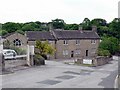
Brookfoot House, Brookfoot Mills, Horsforth
Brookfoot Mills belongs to Stephenson Group Ltd http://www.stephensongroupuk.com/manufacturing.htm
It has a long history as an industrial site, you can read more in "Woodside and its Industries" a Horsforth History Guide published by Horsforth Village Publications, ISBN 0947904026
Image: © Rich Tea
Taken: 26 May 2008
0.01 miles
2
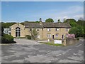
Brookfoot House and Peartree Cottage, Horsforth
This group of buildings from the late 17th century is listed grade 2 (list entry 1261242) and at one time formed part of Stephenson's leather works. See also Image
Image: © Stephen Craven
Taken: 8 May 2016
0.01 miles
3
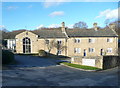
Brookfoot House, Low Lane, Horsforth
This is a 17C house altered in the 18C and listed, Grade II along with the 18C cottages on each side. The listing details do not mention the part on the left with the tall round-headed window.
Image: © Humphrey Bolton
Taken: 9 Mar 2019
0.01 miles
4
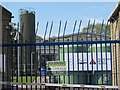
Stephenson Group, Horsforth, entrance
Stephenson's have occupied this site since the mid 19th century, originally a soap works, now making "speciality chemicals".
Image: © Stephen Craven
Taken: 8 May 2016
0.01 miles
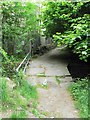
5
Brookfoot Bridge, Horsforth
This bridge, which spans Oil Mill Beck, is thought to be on one of the earliest routes into Horsforth, long before the railways came.
Image: © Dr Neil Clifton
Taken: 7 Apr 2008
0.01 miles
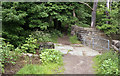
6

Oil Mill Beck from Brookfoot Bridge, Horsforth
Looking downstream from the bridge.
Image: © Rich Tea
Taken: 26 May 2008
0.01 miles
7
Brookfoot Bridge, Horsforth
Looking at the end of Hamers Lane, named after the Hamer family who owned Brookfoot Mills in the mid 19th century, where they made paper.
See the bridge from the other side Image]
Image: © Rich Tea
Taken: 26 May 2008
0.01 miles
8
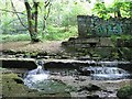
Weir by Brookfoot Mill, Horsforth
A weir on Oil Mill Beck.
Image: © Rich Tea
Taken: 26 May 2008
0.01 miles
9
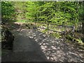
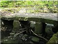
Clapper bridge at Brookfoot: end view
Most clapper bridges (simple spans of stone slabs) are quite ancient, but this one is thought only to date from the 17th century, probably reconstructed c1845. The bridge spans the Oil Mill Beck and is grade 2 listed (list entry 1119686). The steel handrail is obviously a modern addition. See also Image
Image: © Stephen Craven
Taken: 8 May 2016
0.03 miles
10
Clapper bridge at Brookfoot: side view
Most clapper bridges (simple spans of stone slabs) are quite ancient, but this one is thought only to date from the 17th century, probably reconstructed c1845. The bridge spans the Oil Mill Beck and is grade 2 listed (list entry 1119686). The steel handrail is obviously a modern addition. The tree branches were probably washed downstream in the floods of winter 2015/16. See also Image
Image: © Stephen Craven
Taken: 8 May 2016
0.03 miles