IMAGES TAKEN NEAR TO
Troy Hill, LEEDS, LS18 5NH
Introduction
This page details the photographs taken nearby to Troy Hill, LS18 5NH by members of the Geograph project.
The Geograph project started in 2005 with the aim of publishing, organising and preserving representative images for every square kilometre of Great Britain, Ireland and the Isle of Man.

There are currently over 7.5m images from over14,400 individuals and you can help contribute to the project by visiting https://www.geograph.org.uk
Image Map
Images are licensed for reuse under creativecommons.org/licenses/by-sa/2.0
Notes
- Clicking on the map will re-center to the selected point.
- The higher the marker number, the further away the image location is from the centre of the postcode.
Image Listing (220 Images Found)
Images are licensed for reuse under creativecommons.org/licenses/by-sa/2.0
Image
Details
Distance
1
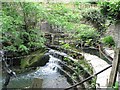
Weir and sluice above Troy Mills, Horsforth
The sluice, on the far side of the picture, would have fed water to Troy Mills, to drive the machinery.
Image: © Rich Tea
Taken: 26 May 2008
0.04 miles
2
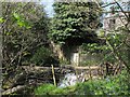
Weir above Troy Mills
The weir on the Oil Mill Beck was to divert water into the millrace for Troy Mills, a nearby leatherworks. It had become more overgrown since RichTea's photo 8 years earlier Image
Image: © Stephen Craven
Taken: 8 May 2016
0.04 miles
3
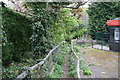
Horsforth: Footpath down from Lister Hill
This is thought to be part of a very old pedestrian route. This part leads down to Low Lane.
Image: © Dr Neil Clifton
Taken: 14 Apr 2011
0.04 miles
4
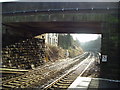
Horsforth Station Bridge
Looking south from the end of the platform of Horsforth Station
Image: © Rich Tea
Taken: 14 Jan 2006
0.05 miles
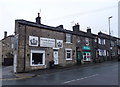
7

Horsforth Dental Practice - Troy Road
Image: © Betty Longbottom
Taken: 19 Aug 2011
0.06 miles
8
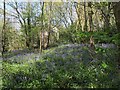
Bluebells in woodland near Troy Mills
2016 was a good year for bluebells after a wet winter.
Image: © Stephen Craven
Taken: 8 May 2016
0.06 miles
9
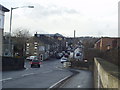
Station Road, Horsforth
Looking west from the railway bridge. Just beyond the bridge on the left is the junction with Troy Road, which leads to Low Lane.
Image: © Rich Tea
Taken: 14 Jan 2006
0.06 miles
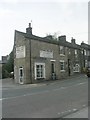
10
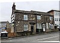
Nos. 28 and 26 Station Road
Ordnance Survey records indicate that a benchmark levelled at 118.439m above Newlyn Datum was verified in 1957 on the front of the left hand house at its left hand corner where a wall abuts.
Image: © Roger Templeman
Taken: 4 Feb 2023
0.06 miles