IMAGES TAKEN NEAR TO
New Road Side, LEEDS, LS18 4NG
Introduction
This page details the photographs taken nearby to New Road Side, LS18 4NG by members of the Geograph project.
The Geograph project started in 2005 with the aim of publishing, organising and preserving representative images for every square kilometre of Great Britain, Ireland and the Isle of Man.

There are currently over 7.5m images from over14,400 individuals and you can help contribute to the project by visiting https://www.geograph.org.uk
Image Map (Loading...)


Getting Data...Please wait
Leaflet Map data © OpenStreetMap
Images are licensed for reuse under creativecommons.org/licenses/by-sa/2.0
Notes
- Clicking on the map will re-center to the selected point.
- The higher the marker number, the further away the image location is from the centre of the postcode.
Image Listing (390 Images Found)
Images are licensed for reuse under creativecommons.org/licenses/by-sa/2.0
Image
Details
Distance
1
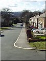
Regent Avenue, Horsforth
Looking south west from the junction of Regent Crescent.
Image: © Rich Tea
Taken: 28 Feb 2006
0.01 miles
2
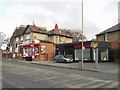
Sandwich bar and Newsagents, New Road Side
Looking north across New Road Side from the end of Newlay Lane. The sandwich bar is at the corner of Regent Avenue.
15 years later, in 2021, the newsagents has closed, and the sandwich bar has become the showroom of Rainbow Windows who supply double glazing.
Image: © Rich Tea
Taken: 19 Mar 2006
0.01 miles
3
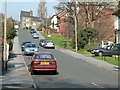
Regent Avenue, Horsforth
Looking up this steep hill from New Road Side.
Image: © Rich Tea
Taken: 25 Mar 2007
0.02 miles
4
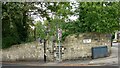
Horsforth, Newlay Lane
There is a benchmark cut into a stone in the road side wall on the north side of the lane.
Image: © Mel Towler
Taken: 3 Sep 2022
0.02 miles
5
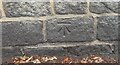
Horsforth, Newlay Lane
The benchmark is cut into a stone in the road side wall on the north side of the lane.
Image: © Mel Towler
Taken: 3 Sep 2022
0.02 miles
6
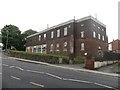
Horsforth telephone exchange
At the junction of Featherbank Lane and New Road Side.
Image: © Rich Tea
Taken: 25 Mar 2007
0.03 miles
7
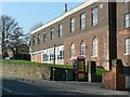
Horsforth telephone exchange, Leeds
The large building which houses the telephone exchange for lines serving the Horsforth area of Leeds.
Image: © Graham Robson
Taken: 2 Aug 2015
0.03 miles
8
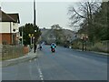
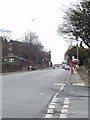
Puffin crossing, New Road Side, Horsforth
This one at the bottom of Featherbank Lane is the last of five in one kilometre on the A65 east of Horsforth roundabout.
Image: © Stephen Craven
Taken: 6 Mar 2021
0.03 miles
9
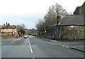
New Road Side, Horsforth
Looking west. The end of Outwood Lane in the foreground, Regent Avenue beyond the bus stop on the right, and Newlay Lane beyond the building on the left.
Image: © Rich Tea
Taken: 28 Feb 2006
0.03 miles
10
New Road Side and Clarence Road
Looking along New Road Side (A65) towards Leeds City Centre. The junction of Clarence Road on the right, and Featherbank Lane on the left. The buildings on the corner of Clarence Road are part of the Froebelian School.(Not taken while driving, as it may seem, but quickly taken while crossing the road)
Image: © Rich Tea
Taken: 9 Apr 2006
0.03 miles