IMAGES TAKEN NEAR TO
Mill Square, LEEDS, LS18 4GJ

Introduction

This page details the photographs taken nearby to Mill Square, LS18 4GJ by members of the Geograph project.

The Geograph project started in 2005 with the aim of publishing, organising and preserving representative images for every square kilometre of Great Britain, Ireland and the Isle of Man.

There are currently over 7.5m images from over14,400 individuals and you can help contribute to the project by visiting https://www.geograph.org.uk

Image Map


Images are licensed for reuse under creativecommons.org/licenses/by-sa/2.0
Notes
  • Clicking on the map will re-center to the selected point.
  • The higher the marker number, the further away the image location is from the centre of the postcode.

Image Listing (127 Images Found)

Images are licensed for reuse under creativecommons.org/licenses/by-sa/2.0
  • ...
Image
Details
Distance
1
Redrow - The Limes at Horsforth Vale Calverley Lane, Horsforth, Leeds
Image: © Mark Stevenson Taken: 24 Jul 2016
0.01 miles
2
Mill Chimney
Seen from the tow-path of the Leeds & Liverpool canal, and looking across the Leeds to Shipley railway line. The top of this chimney is unusual, making it look rather like a crayon. It has been fitted with a 'gas efflux velocity cone'. This is often fitted to chimneys that have been shortened and lost some natural draft. The cone accelerates the gases as they pass through its reduced diameter and act to restore the lost draught. (Thanks to Chris Allen for the information about the cone).
Image: © Rich Tea Taken: 7 Feb 2009
0.03 miles
3
No, it's not a pencil
Chimney viewed from the canal has a cone-built on top to increase the speed of flue gases which makes it look like a giant pencil.
Image: © Joan Murfitt Taken: 28 Jun 2012
0.06 miles
4
Footbridge over the Gill Beck
Near its confluence with the river Aire.
Image: © Stephen Craven Taken: 14 Jul 2019
0.07 miles
5
Riverside path and footbridge
Looking south-westward with the River Aire to the left.
Image: © Peter Wood Taken: 17 Apr 2018
0.07 miles
6
River Aire near Rawdon
Just upstream from the confluence with the Gill Beck.
Image: © Stephen Craven Taken: 14 Jul 2019
0.08 miles
7
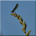
Damselfly on a seed head
Like many insects, it looks less attractive the closer you look. But they are a marvel of nature. Thanks to fellow contributor Hugh Venables for identifying it as 'most likely a female Banded Demoiselle', known to be found in this area. The context is an unmown margin at the edge of urban grassland Image
Image: © Stephen Craven Taken: 28 Jul 2024
0.08 miles
8
West end of the Horsforth Vale estate
These latest houses are named Riverside View; the photo is taken from just off the riverside path, so not an unreasonable name. The area in the foreground looks to have been recently finished with topsoil and is presumably intended to be green open space going down to the river.
Image: © Stephen Craven Taken: 14 Jul 2019
0.09 miles
9
Low Mill, Rawdon, Leeds
Low Mill was originally built in 1797, and was the first of three mills, the others being Park Mill (1805) and Larkfield Mill (1825), to be erected by the Thompson family in Rawdon. Most of Low Mill was demolished in 2016 with only two listed buildings remaining.
Image: © Mark Stevenson Taken: 21 Apr 2014
0.10 miles
10
Low Mill, Rawdon, Leeds
Low Mill was originally built in 1797, and was the first of three mills, the others being Park Mill (1805) and Larkfield Mill (1825), to be erected by the Thompson family in Rawdon. Most of Low Mill was demolished in 2016 with only two listed buildings remaining.
Image: © Mark Stevenson Taken: 27 Apr 2014
0.10 miles
  • ...