IMAGES TAKEN NEAR TO
Laurel Close, LEEDS, LS17 9HS
Introduction
This page details the photographs taken nearby to Laurel Close, LS17 9HS by members of the Geograph project.
The Geograph project started in 2005 with the aim of publishing, organising and preserving representative images for every square kilometre of Great Britain, Ireland and the Isle of Man.

There are currently over 7.5m images from over14,400 individuals and you can help contribute to the project by visiting https://www.geograph.org.uk
Image Map (Loading...)


Getting Data...Please wait
Leaflet Map data © OpenStreetMap
Images are licensed for reuse under creativecommons.org/licenses/by-sa/2.0
Notes
- Clicking on the map will re-center to the selected point.
- The higher the marker number, the further away the image location is from the centre of the postcode.
Image Listing (66 Images Found)
Images are licensed for reuse under creativecommons.org/licenses/by-sa/2.0
Image
Details
Distance
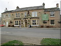
5
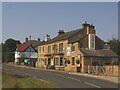
The Duke of Wellington, East Keswick
One of two pubs on Main Street. Described by WhatPub.com as 'Stone-built country pub which re-opened in November 2015.' See also Image
Image: © Stephen Craven
Taken: 10 Jun 2023
0.04 miles
9
East Keswick, west side of the road
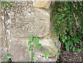
The buttress of this wall is roadside and adjoins the pavement. The wall is to the south [and left] of the Old Star public house. There is a benchmark on the 2nd course of stone which is slightly damaged.
Image: © Mel Towler
Taken: 20 Jun 2021
0.06 miles
10
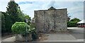
East Keswick, west side of the road
A wider angle of the buttress of the wall which is roadside and adjoins the pavement. The wall is to the south [and left] of the Old Star public house. In the far right there are the beer garden tables. There is a benchmark on the 2nd course of stone which is slightly damaged.
Image: © Mel Towler
Taken: 20 Jun 2021
0.06 miles