IMAGES TAKEN NEAR TO
Sandhill Lawns, Sandhill Lane, LEEDS, LS17 6TT
Introduction
This page details the photographs taken nearby to Sandhill Lawns, Sandhill Lane, LS17 6TT by members of the Geograph project.
The Geograph project started in 2005 with the aim of publishing, organising and preserving representative images for every square kilometre of Great Britain, Ireland and the Isle of Man.

There are currently over 7.5m images from over14,400 individuals and you can help contribute to the project by visiting https://www.geograph.org.uk
Image Map
Images are licensed for reuse under creativecommons.org/licenses/by-sa/2.0
Notes
- Clicking on the map will re-center to the selected point.
- The higher the marker number, the further away the image location is from the centre of the postcode.
Image Listing (123 Images Found)
Images are licensed for reuse under creativecommons.org/licenses/by-sa/2.0
Image
Details
Distance
2
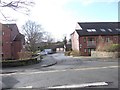
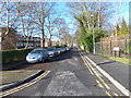
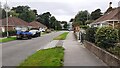
Sandhill Lane
Quiet residential lane in Moor Allerton, Leeds
Image: © Chris Heaton
Taken: 23 Jan 2019
0.04 miles
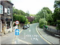
6
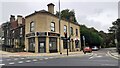
Shops and houses at junction of Harrogate Road and Sandhill Lane
Image: © Roger Templeman
Taken: 24 Aug 2023
0.08 miles
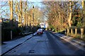
9
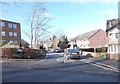
View west along High Moor Crescent towards Shadwell Lane
Image: © Luke Shaw
Taken: 24 Aug 2023
0.10 miles
10
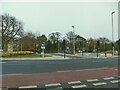
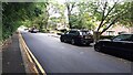
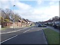
Cycle lanes across Moortown roundabout
Moortown roundabout is at the junction of the A61 with three other roads. It is a complicated junction, close to the Moor Allerton roundabout where the A61 meets the ring road, and until recently was regarded as a barrier to active travel. See Image for a view from several years ago. Major investment by the city council in 2019/20 has provided safe cycle lanes and pedestrian/cycle crossings (toucans) throughout the double junction. But I still found it confusing the first time I tried to use the cycle lanes.
Image: © Stephen Craven
Taken: 7 Nov 2020
0.10 miles