IMAGES TAKEN NEAR TO
Harrogate Road, LEEDS, LS17 6DN
Introduction
This page details the photographs taken nearby to Harrogate Road, LS17 6DN by members of the Geograph project.
The Geograph project started in 2005 with the aim of publishing, organising and preserving representative images for every square kilometre of Great Britain, Ireland and the Isle of Man.

There are currently over 7.5m images from over14,400 individuals and you can help contribute to the project by visiting https://www.geograph.org.uk
Image Map (Loading...)


Getting Data...Please wait
Leaflet Map data © OpenStreetMap
Images are licensed for reuse under creativecommons.org/licenses/by-sa/2.0
Notes
- Clicking on the map will re-center to the selected point.
- The higher the marker number, the further away the image location is from the centre of the postcode.
Image Listing (124 Images Found)
Images are licensed for reuse under creativecommons.org/licenses/by-sa/2.0
Image
Details
Distance
1
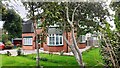
#389 Harrogate Road
Ordnance Survey documents indicate that a benchmark was levelled at 137.552m above Newlyn Datum on the near corner of the house in 1990
Image: © Roger Templeman
Taken: 24 Aug 2023
0.05 miles
5
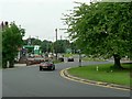
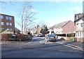
Harrogate Road roundabout, Moortown, Leeds
The junction of Harrogate Road with Stonegate Road, Scott Hall Road and Sand Hill Lane.
Image: © Rich Tea
Taken: 7 Jun 2008
0.07 miles
6
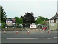
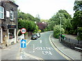
This will be Belgravia
A couple of Victorian or Edwardian houses have been demolished along Harrogate Road at Moortown in Leeds, to make way for a development of apartments to be known as The Belgravia.
Image: © Rich Tea
Taken: 7 Jun 2008
0.07 miles
8
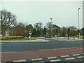
Cycle lanes across Moortown roundabout
Moortown roundabout is at the junction of the A61 with three other roads. It is a complicated junction, close to the Moor Allerton roundabout where the A61 meets the ring road, and until recently was regarded as a barrier to active travel. See Image for a view from several years ago. Major investment by the city council in 2019/20 has provided safe cycle lanes and pedestrian/cycle crossings (toucans) throughout the double junction. But I still found it confusing the first time I tried to use the cycle lanes.
Image: © Stephen Craven
Taken: 7 Nov 2020
0.08 miles
9
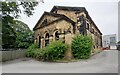
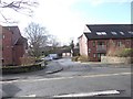
Former synagogue on SE side of Shadwell Lane
Now used as offices, and behind the fence is Moortown Montessori Nursery. Ordnance Survey documents indicated that a benchmark levelled at 142.714m above Newlyn Datum was verified in 1957 on the left hand corner of the building.
Image: © Roger Templeman
Taken: 24 Aug 2023
0.08 miles
10
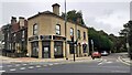
Shops and houses at junction of Harrogate Road and Sandhill Lane
Image: © Roger Templeman
Taken: 24 Aug 2023
0.08 miles