IMAGES TAKEN NEAR TO
Church View, LEEDS, LS14 3ED
Introduction
This page details the photographs taken nearby to Church View, LS14 3ED by members of the Geograph project.
The Geograph project started in 2005 with the aim of publishing, organising and preserving representative images for every square kilometre of Great Britain, Ireland and the Isle of Man.

There are currently over 7.5m images from over14,400 individuals and you can help contribute to the project by visiting https://www.geograph.org.uk
Image Map
Images are licensed for reuse under creativecommons.org/licenses/by-sa/2.0
Notes
- Clicking on the map will re-center to the selected point.
- The higher the marker number, the further away the image location is from the centre of the postcode.
Image Listing (113 Images Found)
Images are licensed for reuse under creativecommons.org/licenses/by-sa/2.0
Image
Details
Distance
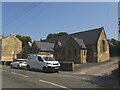
1
St Peter's Parish Centre - Church View, Thorner
Image: © Betty Longbottom
Taken: 3 Sep 2008
0.00 miles
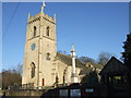
2
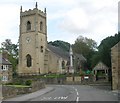
St Peter's Church - Church View, Thorner
Image: © Betty Longbottom
Taken: 3 Sep 2008
0.01 miles
3
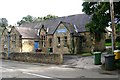
Thorner Parish Centre
Built as a parish school in 1787.
Image: © Stephen Craven
Taken: 10 Jun 2023
0.01 miles
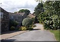

6

Church View, Thorner
Looking down Main Street in the West Yorkshire village of Thorner, towards St. Peter's Church
Image: © Chris Heaton
Taken: 28 Jan 2016
0.02 miles
7
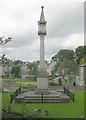
War Memorial - St Peter's Churchyard, Church View, Thorner
Image: © Betty Longbottom
Taken: 3 Sep 2008
0.03 miles
9
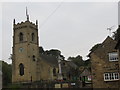
The Church of St Peter at Thorner
Viewed from the south-west.
Image: © Peter Wood
Taken: 3 Sep 2014
0.03 miles