IMAGES TAKEN NEAR TO
Heather Grove, LEEDS, LS13 4LE
Introduction
This page details the photographs taken nearby to Heather Grove, LS13 4LE by members of the Geograph project.
The Geograph project started in 2005 with the aim of publishing, organising and preserving representative images for every square kilometre of Great Britain, Ireland and the Isle of Man.

There are currently over 7.5m images from over14,400 individuals and you can help contribute to the project by visiting https://www.geograph.org.uk
Image Map
Images are licensed for reuse under creativecommons.org/licenses/by-sa/2.0
Notes
- Clicking on the map will re-center to the selected point.
- The higher the marker number, the further away the image location is from the centre of the postcode.
Image Listing (125 Images Found)
Images are licensed for reuse under creativecommons.org/licenses/by-sa/2.0
Image
Details
Distance
1
Old wall on the route of Boggard Lane
This urban footpath is a right of way, and follows the route of an old road called Boggard Lane. The route of most of the lane has been obliterated by the post-war Gamble Hill estate, and at the northern end it has been diverted around the edge of the bus depot Image, but the low stone wall in this photo is evidence of the old road alignment.
Image: © Stephen Craven
Taken: 30 Sep 2015
0.03 miles
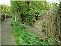
2
Path on the route of Boggard Lane
This urban footpath is a right of way, and follows the route of an old road called Boggard Lane. The route of most of the lane has been obliterated by the post-war Gamble Hill estate, and at the northern end it has been diverted around the edge of the bus depot Image, but this stretch is on the old road alignment. See also Image
Image: © Stephen Craven
Taken: 30 Sep 2015
0.03 miles
4
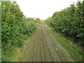
Railway east of Boggard Lane
Viewed from a footbridge Image
Image: © Stephen Craven
Taken: 30 Sep 2015
0.05 miles
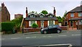
5
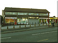
Henconner Lane shops
As of 2015 the row of shops consisted of a Chinese takeaway, hairdresser, barber (formerly a tanning salon Image ), florist (formerly a pharmacy Image ), and pizza takeaway.
Image: © Stephen Craven
Taken: 29 Aug 2015
0.05 miles
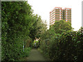
6
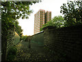
Railway footbridge on Boggard Lane
This urban footpath is a right of way, and follows the route of an old road called Boggard Lane. The route of most of the lane has been obliterated by the post-war Gamble Hill estate, and at the northern end it has been diverted around the edge of the bus depot Image, but this stretch is on the old road alignment as evidenced by the older stone walls of the bridge abutment. See also Image
Image: © Stephen Craven
Taken: 30 Sep 2015
0.05 miles
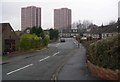
7
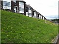
August dandelions
August seems rather late in the year for this fine display of dandelions, usually thought of as a spring flower. But the plantlife.org.uk website says they can flower as late as October. For a wider view of the houses behind, see Image
Image: © Stephen Craven
Taken: 6 Aug 2021
0.05 miles
8
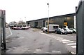
Bramley Bus Depot - Henconner Lane
Image: © Betty Longbottom
Taken: 20 Nov 2007
0.05 miles
9
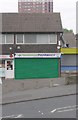
henconner Pharmacy - Henconner Lane
Image: © Betty Longbottom
Taken: 29 Apr 2011
0.05 miles