IMAGES TAKEN NEAR TO
Green Hill Mount, LEEDS, LS13 4AL
Introduction
This page details the photographs taken nearby to Green Hill Mount, LS13 4AL by members of the Geograph project.
The Geograph project started in 2005 with the aim of publishing, organising and preserving representative images for every square kilometre of Great Britain, Ireland and the Isle of Man.

There are currently over 7.5m images from over14,400 individuals and you can help contribute to the project by visiting https://www.geograph.org.uk
Image Map
Images are licensed for reuse under creativecommons.org/licenses/by-sa/2.0
Notes
- Clicking on the map will re-center to the selected point.
- The higher the marker number, the further away the image location is from the centre of the postcode.
Image Listing (279 Images Found)
Images are licensed for reuse under creativecommons.org/licenses/by-sa/2.0
Image
Details
Distance
1

Green Hill Mount - Green Hill Lane
Image: © Betty Longbottom
Taken: 29 Apr 2011
0.01 miles
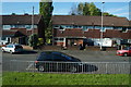
2
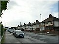
Green Hill Mount
This used to be a through road to Stanningley Road but since the latter was realigned to be the start of the Stanningley Bypass, Green Hill Mount is a dead-end street (behind the camera).
Image: © Stephen Craven
Taken: 1 Nov 2020
0.01 miles
3
Green Hill Place - Green Hill Lane
Image: © Betty Longbottom
Taken: 29 Apr 2011
0.05 miles
4
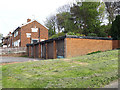
Lock-up garages, Green Hill Road, Bramley
Image: © Stephen Craven
Taken: 18 Apr 2020
0.05 miles
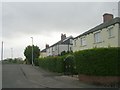
5

Green Hill Mount, Bramley
Viewed from the top deck of a number 16 bus.
Image: © Stephen Craven
Taken: 2 Jun 2016
0.05 miles
6
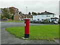
Postbox at the end of Green Hill Mount
A standard E II R pillar box.
Image: © Stephen Craven
Taken: 1 Nov 2020
0.06 miles
8
Police waiting area on Stanningley Road (2)
One of at least four locations along the dual carriageway section of Stanningley Road created in the last year or so for police vehicles to wait, presumably as part of speed trap operations. This one is at the bottom of the slip road from Town End roundabout.
Image: © Stephen Craven
Taken: 27 Mar 2021
0.06 miles
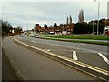
9
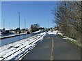
Cycle lane on Stanningley Road
This shows that the 'cycle superhighway' between Bradford and Leeds does get gritted in wintry conditions. The snow-covered area between this and the traffic lanes is a police vehicle waiting area Image
Image: © Stephen Craven
Taken: 10 Mar 2023
0.06 miles
10
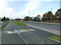
Bus stop on Stanningley Road
The stop is served by services to Bradford: the all-stops 72 which turns off the main road here to go through Bramley and Stanningley, and the limited-stop X6 which stays on the ring road to Pudsey. Next to it is the Leeds-Bradford cycleway.
Image: © Stephen Craven
Taken: 1 Nov 2020
0.06 miles