IMAGES TAKEN NEAR TO
Snowden Royd, LEEDS, LS13 2UJ
Introduction
This page details the photographs taken nearby to Snowden Royd, LS13 2UJ by members of the Geograph project.
The Geograph project started in 2005 with the aim of publishing, organising and preserving representative images for every square kilometre of Great Britain, Ireland and the Isle of Man.

There are currently over 7.5m images from over14,400 individuals and you can help contribute to the project by visiting https://www.geograph.org.uk
Image Map
Images are licensed for reuse under creativecommons.org/licenses/by-sa/2.0
Notes
- Clicking on the map will re-center to the selected point.
- The higher the marker number, the further away the image location is from the centre of the postcode.
Image Listing (373 Images Found)
Images are licensed for reuse under creativecommons.org/licenses/by-sa/2.0
Image
Details
Distance
1
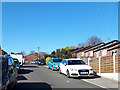
Snowden Royd, Bramley
'Royd' in historical Yorkshire place names strictly means a clearing in the woods. Its use here has no such significance, being just one of many suffixes to the name 'Snowden' for the roads on a housing estate.
Image: © Stephen Craven
Taken: 14 Apr 2020
0.02 miles
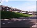
2
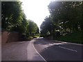
Out Gang, Bramley
Lower down, the road is called Outgang Lane, but this end nearest the town centre is simply Out Gang. The name, like the road, is an ancient one, from when Bramley was no more than a hilltop village, and perhaps referring to the road "going out" of the village. As late as 1895, the Ordnance Survey map shows only one building between here and Kirkstall Brewery three-quarters of a mile away. The road is now cut off to through motor traffic at the top end, giving access only to a modern residential development.
This is a view up the hill: see Image for a view looking downhill from the same spot.
Image: © Stephen Craven
Taken: 28 May 2016
0.02 miles
3
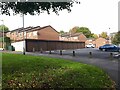
Car park and garages at the top of Snowden Royd
The car park, and the road leading to it, have recently been resurfaced. It provides free parking for residents of a number of blocks of flats on the Snowden estate that don't have direct vehicle access.
Image: © Stephen Craven
Taken: 18 Oct 2023
0.03 miles
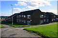
4
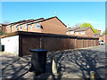
Lock-up garages at the top of Snowden Royd, Bramley
Image: © Stephen Craven
Taken: 14 Apr 2020
0.03 miles
5
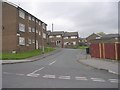
Out Gang, Bramley with modern housing
Lower down, the road is called Outgang Lane, but this end nearest the town centre is simply Out Gang. The name, like the road, is an ancient one, from when Bramley was no more than a hilltop village, and perhaps referring to the road "going out" of the village. As late as 1895, the Ordnance Survey map shows only one building between here and Kirkstall Brewery three-quarters of a mile away. The road is now cut off to through motor traffic at the top end, giving access only to a modern residential development.
This is a view down the hill: see Image for a view looking downhill from the same spot.
Image: © Stephen Craven
Taken: 28 May 2016
0.04 miles
7

Path behind Snowden Royd
This path is part of a longer pedestrian route from Lower Town Street to the Raynville estate.
Image: © Stephen Craven
Taken: 27 Jun 2020
0.04 miles
8
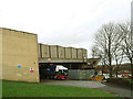
Last minute delivery to Tesco
Just after noon on Christmas Eve, and the Bramley supermarket was still getting deliveries to replenish the shelves as customers did their frantic last-minute shopping.
Image: © Stephen Craven
Taken: 24 Dec 2016
0.05 miles
10
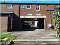
Path through buildings at the top of Snowden Royd, Bramley
The 'flat arch' created by placing rooms of a house over a public route from one side of a building to the other was a common feature of earlier terraced housing in Yorkshire (especially 'back-to-backs') but less often seen as here in late 20th century council housing.
Image: © Stephen Craven
Taken: 14 Apr 2020
0.06 miles