IMAGES TAKEN NEAR TO
Blairsville Grove, LEEDS, LS13 2HT
Introduction
This page details the photographs taken nearby to Blairsville Grove, LS13 2HT by members of the Geograph project.
The Geograph project started in 2005 with the aim of publishing, organising and preserving representative images for every square kilometre of Great Britain, Ireland and the Isle of Man.

There are currently over 7.5m images from over14,400 individuals and you can help contribute to the project by visiting https://www.geograph.org.uk
Image Map
Images are licensed for reuse under creativecommons.org/licenses/by-sa/2.0
Notes
- Clicking on the map will re-center to the selected point.
- The higher the marker number, the further away the image location is from the centre of the postcode.
Image Listing (354 Images Found)
Images are licensed for reuse under creativecommons.org/licenses/by-sa/2.0
Image
Details
Distance
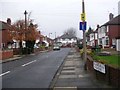
2
Broad Lane, Bramley, east of Upper Town Street
This was at one time the main road from Leeds to Bradford, before the Leeds and Bradford Road was built lower down the hill, and later the Stanningley Bypass.
To the left is a postbox.
Image: © Stephen Craven
Taken: 24 Dec 2018
0.03 miles
3
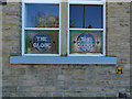
Window in the former Globe pub
The name of the former pub Image is preserved in this front window of what is now a funeral directors business Image
Image: © Stephen Craven
Taken: 19 Apr 2020
0.04 miles
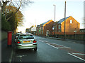
4
Hill Court Avenue - Hill Court Drive
Image: © Betty Longbottom
Taken: 13 Apr 2011
0.04 miles
5
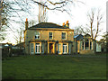
The Willows, Broad Lane, Bramley
This is a large 19th century villa on the edge of Bramley. On the gatepost there is a sign for the Kingdom Hall; the actual place of worship is behind the house (and can be glimpsed to the left of this photo) but I am unsure whether the Jehovah's Witnesses also own the house itself.
Image: © Stephen Craven
Taken: 24 Dec 2018
0.05 miles
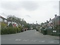
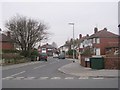
6
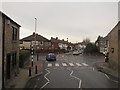
Junction of Upper Town Street and Broad Lane
The A657 road does a dog-leg here (left and right). The road straight on is Blairsville Grove, a dead-end.
Taken from the top deck of the 86 bus to Rodley.
Image: © Stephen Craven
Taken: 16 Jan 2016
0.05 miles
7
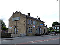
The Globe, Bramley - closed
The Globe pub (see also Image ) shut in summer 2017. It was being advertised for lease so there is a possibility of it reopening as a pub, although the trend these days is for closed pubs to become shops or other businesses.
Image: © Stephen Craven
Taken: 20 Aug 2017
0.05 miles
8
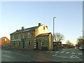
The former Globe pub, Broad Lane, Bramley
The pub closed in 2017 Image but 16 months later had not yet reopened in its new role as a funeral director's premises.
The Zebra crossing is at the start of Upper Town Street, that leads to Bramley town centre.
Image: © Stephen Craven
Taken: 24 Dec 2018
0.05 miles
9
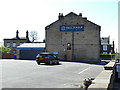
Full Circle Funerals, Broad Lane, Bramley
The name is that of a business with several branches across Yorkshire, so it is just a nice coincidence that they occupy a building formerly known as the Globe pub Image
Image: © Stephen Craven
Taken: 19 Apr 2020
0.05 miles
10
Blairsville Gardens - Whitecote Hill
Image: © Betty Longbottom
Taken: 7 Mar 2011
0.06 miles