IMAGES TAKEN NEAR TO
Rutland Court, LEEDS, LS12 6BU
Introduction
This page details the photographs taken nearby to Rutland Court, LS12 6BU by members of the Geograph project.
The Geograph project started in 2005 with the aim of publishing, organising and preserving representative images for every square kilometre of Great Britain, Ireland and the Isle of Man.

There are currently over 7.5m images from over14,400 individuals and you can help contribute to the project by visiting https://www.geograph.org.uk
Image Map
Images are licensed for reuse under creativecommons.org/licenses/by-sa/2.0
Notes
- Clicking on the map will re-center to the selected point.
- The higher the marker number, the further away the image location is from the centre of the postcode.
Image Listing (77 Images Found)
Images are licensed for reuse under creativecommons.org/licenses/by-sa/2.0
Image
Details
Distance
1
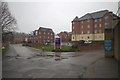
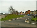
New Housing Development off Royds Lane
Royds Lane used to continue to the left of the photograph and pass through a tunnel under the railway line. This section has been renamed Honeybourne Road and it climbs the hill to the right. The Development has been built by Taylor Wimpey and is called Royds Lane Mount. The road to the right of the photograph is the service / deliveries access to the Makro wholesale warehouse.
Image: © Mark Anderson
Taken: 15 Mar 2018
0.04 miles
2
Electricity substation, Honeybourne Road
Serving the new Royds Lane housing estate. See https://westleedsdispatch.com/marks-history-reminders-of-past-in-new-wortley-housing-estate/ for a photo of Honeybourne Road before the housing development.
Image: © Stephen Craven
Taken: 31 Jan 2021
0.05 miles
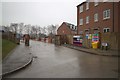
3
Makro-Booker, Royds Lane
A large wholesale warehouse.
Image: © Stephen Craven
Taken: 31 Jan 2021
0.06 miles
4
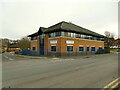
Constant Travel, Royds Lane
Headquarters of a travel agency business.
Image: © Stephen Craven
Taken: 31 Jan 2021
0.06 miles
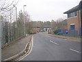
5
Pullman Crescent
The name refers to luxury trains of the 20th century, and was chosen presumably because the birch-covered embankment to the left marks the course of a former railway - one which I'm sure never saw a Pullman train, and probably not even a passenger train, as it was a freight branch to the Farnley Ironworks. See https://westleedsdispatch.com/marks-history-reminders-of-past-in-new-wortley-housing-estate/ for a photo before the housing development showing the old bridge abutments.
Image: © Stephen Craven
Taken: 31 Jan 2021
0.06 miles
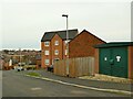
6
Pullman Crescent (under construction)
Part of the Royds Lane Mount housing development. The road follows the route of a disused railway line.
Image: © Mark Anderson
Taken: 15 Mar 2018
0.07 miles
8
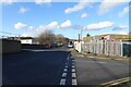
NEW
Royds Lane
The junction of Royds Lane with Pavilion Business Park.
Image: © DS Pugh
Taken: 22 Feb 2025
0.08 miles
9
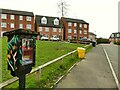
Little Free Library, Uppingham Gardens
One of several such local book exchanges in Leeds.
Image: © Stephen Craven
Taken: 31 Jan 2021
0.08 miles
10
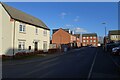
NEW
Piebridge Way
A street in a recent housing development. A footpath runs from here to Gelderd Road.
Image: © DS Pugh
Taken: 22 Feb 2025
0.09 miles