IMAGES TAKEN NEAR TO
Barden Grove, LEEDS, LS12 3EH
Introduction
This page details the photographs taken nearby to Barden Grove, LS12 3EH by members of the Geograph project.
The Geograph project started in 2005 with the aim of publishing, organising and preserving representative images for every square kilometre of Great Britain, Ireland and the Isle of Man.

There are currently over 7.5m images from over14,400 individuals and you can help contribute to the project by visiting https://www.geograph.org.uk
Image Map
Images are licensed for reuse under creativecommons.org/licenses/by-sa/2.0
Notes
- Clicking on the map will re-center to the selected point.
- The higher the marker number, the further away the image location is from the centre of the postcode.
Image Listing (272 Images Found)
Images are licensed for reuse under creativecommons.org/licenses/by-sa/2.0
Image
Details
Distance
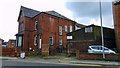
2
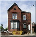
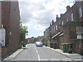
The Alliance Buildings - 188 Whingate
These were built in the late 1880s and are being converted into flats.
Image: © Betty Longbottom
Taken: 21 May 2007
0.01 miles

6
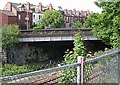
Road Bridge No LBE1 II over Railway Line - Whingate
Image: © Betty Longbottom
Taken: 21 May 2007
0.03 miles
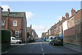
10
Alliance Street - Conference Road
Image: © Betty Longbottom
Taken: 31 May 2011
0.03 miles