IMAGES TAKEN NEAR TO
Houghley Crescent, LEEDS, LS12 2TQ
Introduction
This page details the photographs taken nearby to Houghley Crescent, LS12 2TQ by members of the Geograph project.
The Geograph project started in 2005 with the aim of publishing, organising and preserving representative images for every square kilometre of Great Britain, Ireland and the Isle of Man.

There are currently over 7.5m images from over14,400 individuals and you can help contribute to the project by visiting https://www.geograph.org.uk
Image Map
Images are licensed for reuse under creativecommons.org/licenses/by-sa/2.0
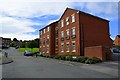
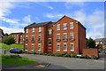
Notes
- Clicking on the map will re-center to the selected point.
- The higher the marker number, the further away the image location is from the centre of the postcode.
Image Listing (284 Images Found)
Images are licensed for reuse under creativecommons.org/licenses/by-sa/2.0
Image
Details
Distance
1
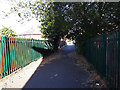
Footpath from Raynville Crescent to Wyther Park Hill
Image: © Stephen Craven
Taken: 31 May 2020
0.02 miles
2
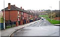
Raynville Crescent - Raynville Road
Image: © Betty Longbottom
Taken: 17 Nov 2008
0.03 miles
3
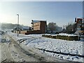
The bottom of Raynville Crescent in the snow
Raynville Road (right) had been gritted but the Crescent had not.
Image: © Stephen Craven
Taken: 15 Jan 2021
0.04 miles
4
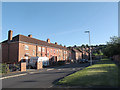
Bottom end of Raynville Crescent
With houses on one side of the road only, the other being open space.
Image: © Stephen Craven
Taken: 30 Jul 2015
0.04 miles
6
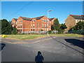
Green area on Wyther Park Hill
This feature is a legacy of the original road layout: Wyther Park Hill as built in the 1920s carried on to the right of the photo, where it is now blocked by a green palisade fence separating this street from Raynville Gardens (a much more recent estate the other side). A through pedestrian route would have been sensible but was not provided. The road in the foreground was a stub off it, but now represents the remainder of Wyther Park Hill.
Image: © Stephen Craven
Taken: 31 May 2020
0.05 miles
7
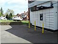
InPost lockers outside Nisa, Raynville Road
Not a very new installation but it appeared within the last couple of years. For context see Image
Image: © Stephen Craven
Taken: 21 Apr 2024
0.05 miles
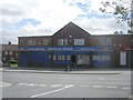
8
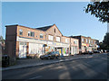
Nisa Local, Raynville Road
A grocery shop nearest the camera, with other shops beyond. It was originally built as a Co-Operative store in the 1930s; the second storey (apart from the bit with a pediment) was added later.
Image: © Stephen Craven
Taken: 30 Jul 2015
0.05 miles