IMAGES TAKEN NEAR TO
Wyther Park Hill, LEEDS, LS12 2SZ
Introduction
This page details the photographs taken nearby to Wyther Park Hill, LS12 2SZ by members of the Geograph project.
The Geograph project started in 2005 with the aim of publishing, organising and preserving representative images for every square kilometre of Great Britain, Ireland and the Isle of Man.

There are currently over 7.5m images from over14,400 individuals and you can help contribute to the project by visiting https://www.geograph.org.uk
Image Map
Images are licensed for reuse under creativecommons.org/licenses/by-sa/2.0
Notes
- Clicking on the map will re-center to the selected point.
- The higher the marker number, the further away the image location is from the centre of the postcode.
Image Listing (336 Images Found)
Images are licensed for reuse under creativecommons.org/licenses/by-sa/2.0
Image
Details
Distance
1
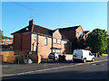
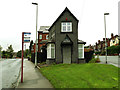
Houses on Wyther Park Hill
This pair of houses is probably part of the original 1920s development although may have been built as four dwellings, later combined to two larger ones. The central gable and arched windows stand out as unusual features.
Image: © Stephen Craven
Taken: 31 May 2020
0.02 miles
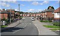
4
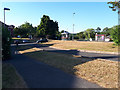
Green area on Wyther Park Hill
This feature is a legacy of the original road layout: Wyther Park Hill as built in the 1920s carried on to the right of the photo, where it is now blocked by a green palisade fence separating this street from Raynville Gardens (a much more recent estate the other side). A through pedestrian route would have been sensible but was not provided. The road in the foreground was a stub off it, but now represents the remainder of Wyther Park Hill.
Image: © Stephen Craven
Taken: 31 May 2020
0.04 miles
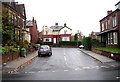
5
Service road parallel to Armley Ridge Road
A short service road with parking area. Comparing old maps, this appears to be the original alignment of Armley Ridge Road, which was realigned at some time in the last 50 years, perhaps to ease the sharp bend at the bottom of the hill known as Amen Corner.
Image: © Stephen Craven
Taken: 31 May 2020
0.04 miles
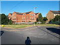
6
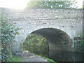
Kirkstall Brewery Bridge
Over the Leeds and Liverpool Canal.
Image: © Mark Morton
Taken: 12 Nov 2005
0.04 miles
7
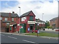
H & A C Binns Newsagents - Raynville Road
Image: © Betty Longbottom
Taken: 8 Aug 2011
0.05 miles
8
Newsagents on Raynville Road
Approaching this building down the road it appeared derelict but in fact it is still open. See also Image There is a bus stop outside.
Image: © Stephen Craven
Taken: 31 Jul 2015
0.05 miles
9
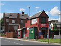
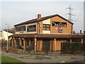
Field Funeral Services, Raynville Road, Bramley
The funeral directors opened in 2019 after renovating this wedge-shaped building formerly occupied by Binns newsagent Image
Image: © Stephen Craven
Taken: 16 Aug 2019
0.05 miles
10
The Ancestor, Armley Ridge Road, Leeds
On the east side of Armley Ridge Road at the corner of Lenhurst Avenue
Image: © Rich Tea
Taken: 24 Jan 2006
0.05 miles