IMAGES TAKEN NEAR TO
Jack Lane, LEEDS, LS11 5NE
Introduction
This page details the photographs taken nearby to Jack Lane, LS11 5NE by members of the Geograph project.
The Geograph project started in 2005 with the aim of publishing, organising and preserving representative images for every square kilometre of Great Britain, Ireland and the Isle of Man.

There are currently over 7.5m images from over14,400 individuals and you can help contribute to the project by visiting https://www.geograph.org.uk
Image Map (Loading...)


Getting Data...Please wait
Leaflet Map data © OpenStreetMap
Images are licensed for reuse under creativecommons.org/licenses/by-sa/2.0
Notes
- Clicking on the map will re-center to the selected point.
- The higher the marker number, the further away the image location is from the centre of the postcode.
Image Listing (142 Images Found)
Images are licensed for reuse under creativecommons.org/licenses/by-sa/2.0
Image
Details
Distance
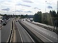
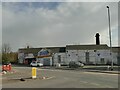
2
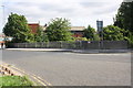
Junction of Jack Lane and Dewsbury Road
Jack Lane was once a continuous road for nearly 2km through Hunslet and Holbeck, but now consists of two unconnected sections, and the eastern ed at Hunslet is pedestrianised. The section of Dewsbury Road that meets it here is a modern alignment since the construction of the M621.
Image: © Stephen Craven
Taken: 2 Apr 2022
0.03 miles
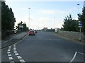
3
View from Dewsbury Road Bridge TJC3-1A
Image: © Betty Longbottom
Taken: 29 Sep 2008
0.03 miles
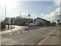
4
Railway bridge TJC3/1A, Dewsbury Road
There is an OS benchmark Image on the concrete part of the parapet at the right hand edge of the image.
Image: © Roger Templeman
Taken: 2 Sep 2013
0.03 miles
5
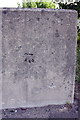
Benchmark on railway bridge parapet, Dewsbury Road
Ordnance Survey cut mark benchmark described on the Bench Mark Database at http://www.bench-marks.org.uk/bm51182
Image: © Roger Templeman
Taken: 2 Sep 2013
0.04 miles
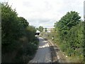
9
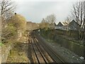
Railway line east of Dewsbury Road
This is the Leeds to Castleford line which now carries a twice-hourly passenger service to Sheffield or Knottingley, and occasional freight. In the heyday of the railways, this was a four-track main line, with a four-track branch off to the left serving the Midland Railway's Crown Point goods depot where a birch wood has grown up (far left), and nearer the camera a mineral line bringing coal from the Middleton collieries to Leeds gas works crossed the line on a bridge - you can just see the left hand abutment.
Image: © Stephen Craven
Taken: 2 Apr 2022
0.07 miles