IMAGES TAKEN NEAR TO
Bowman Lane, LEEDS, LS10 1HF
Introduction
This page details the photographs taken nearby to Bowman Lane, LS10 1HF by members of the Geograph project.
The Geograph project started in 2005 with the aim of publishing, organising and preserving representative images for every square kilometre of Great Britain, Ireland and the Isle of Man.

There are currently over 7.5m images from over14,400 individuals and you can help contribute to the project by visiting https://www.geograph.org.uk
Image Map
Images are licensed for reuse under creativecommons.org/licenses/by-sa/2.0
Notes
- Clicking on the map will re-center to the selected point.
- The higher the marker number, the further away the image location is from the centre of the postcode.
Image Listing (1082 Images Found)
Images are licensed for reuse under creativecommons.org/licenses/by-sa/2.0
Image
Details
Distance
1
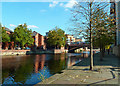
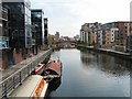
On The Trans-Pennine Trail
This part of the trail uses footpaths along the River Aire in central Leeds. The area has been transformed from its industrial past with new housing and leisure facilities. The road bridge in the background is the Crown Point Bridge.
Image: © Mary and Angus Hogg
Taken: 19 Oct 2018
0.02 miles
3
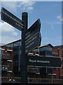
Different types of direction
This signpost stands on the south bank of the River Aire. On the opposite bank is a 1992 development of riverside apartments at Langtons Wharf.
Maybe the signwriter asked an irascible local where the westbound path went and just put down the reply verbatim!
Image: © David Wilkinson
Taken: 11 Aug 2007
0.02 miles
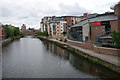
5
River Aire
From the Centenary Bridge looking towards Crown Point Bridge.
Image: © Gerald England
Taken: 23 Apr 2009
0.03 miles
6

River Aire, Leeds
Looking upstream (towards the city centre) from Crown Point Bridge.
Image: © David Dixon
Taken: 24 May 2013
0.03 miles
7
Riverside development viewed from Crown Point Bridge
Image: © Betty Longbottom
Taken: 27 Aug 2007
0.03 miles
8
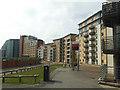
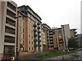
Brewery Wharf, Bowman Lane, Leeds
A substantial residential development on former industrial land along the south bank of the river Aire.
Image: © Stephen Craven
Taken: 17 Jun 2020
0.03 miles
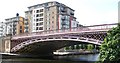
10
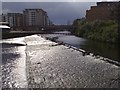
Crown Point Bridge and Weir
Most of the buildings in this area are of 21st century construction, but it is still a nineteenth century bridge that connects them all.
Rain followed shortly after.
Image: © Steve Partridge
Taken: 1 Jul 2008
0.03 miles